
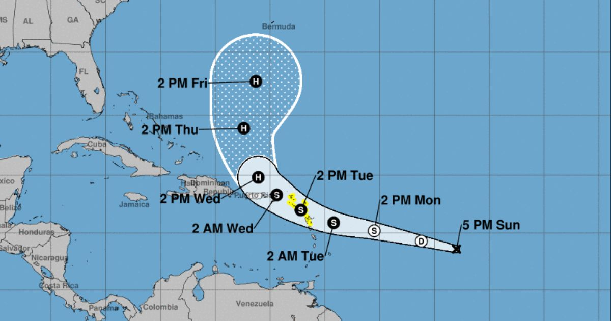
The National Hurricane Center (NHC) issued the first forecast cone for potential Hurricane Ernesto this Sunday, warning that it could develop into a cyclone in five days, although it poses no threat to Florida.
The forecasting models of the NHC indicate that the storm, currently identified as Potential Tropical System #5, will gradually strengthen as it moves through the Atlantic; however, its projected path suggests that it will remain away from the shores of Florida.
However, residents in the countries along Ernesto's potential path were urged to stay informed and follow updates from the NHC, as weather conditions can change rapidly.
"The intense rains could lead to significant flash flooding and landslides in parts of the northern Windward Islands on Tuesday and Wednesday, and in Puerto Rico from Wednesday to Thursday," the institution warned.
This development occurs amid a hurricane season that has shown increasing activity, emphasizing the importance of preparation and constant vigilance by communities in potentially affected areas, the NHC indicated.
Regarding the future trajectory and development of the atmospheric disturbance, meteorologist Matt Devitt stated on Facebook, “This storm will not be a threat to Florida!”
"The two most likely outcomes for Ernesto along the way would either be to curve towards the sea like a 'fish' storm or make landfall in eastern Canada," he notes.
The NHC reported this Sunday that the environmental conditions in the North Atlantic, the Caribbean Sea, and the Gulf of Mexico are favorable for the development of a low-pressure system that could become a tropical depression in the coming days.
According to forecasts, there is an 80% chance that the system will become a tropical depression within the next 48 hours, and a 90% chance that this will happen within the next seven days.
For several days, close monitoring has been maintained of this weather disturbance due to its potential impact on the Caribbean region.
The 2024 hurricane season continues to show signs of intense activity, with the Caribbean facing new weather threats.
The NHC stated that the peak of the season is just around the corner – from late August to late September – and that up to 13 hurricanes could occur in total between June 1 and November 30.
Filed under: