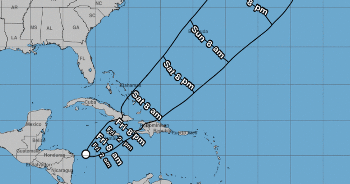
The National General Staff of the Civil Defense of Cuba decreed this Thursday the alert phase due to heavy rains for the eastern provinces.
Given the increased probability of strong and intense rainfall from Las Tunas to Guantánamo, associated with the Tropical depression formed in the Caribbean Sea, the Civil Defense declared an alert phase for the eastern region of the country from six in the afternoon this Thursday.
The statement from the Cuban institution argues for the measure on the fact that "the extensive area of cloudiness with showers, rains and thunderstorms in the Caribbean Sea has been better organized" and taking into account "the complexity of this hydrometeorological event, the probability of the development of the low pressure system in the next 24 to 48 hours, which could become a tropical depression.
However, the United States National Hurricane Center (NHC) announced earlier this Thursday the formation of tropical depression number 22 of the current cyclone season. In its Warning Number 1 of potential tropical cyclone, warned that the disturbance located in the western Caribbean Sea could evolve into a tropical storm.
Likewise, he announced that, in the case of Cuba, the government had issued a Tropical Storm Watch for the provinces of Guantánamo, Santiago de Cuba, Holguín, Granma and Las Tunas.
The Cuban Institute of Meteorology (INSMET) predicted strong and intense rains in the eastern region of Cuba, in its Special Notice No. 1.
The report, issued at 4:00 p.m., indicated that "regardless of the future development of the low pressure zone of the Caribbean Sea, the rains over the eastern region of Cuba will persist from this afternoon, which will be strong in some locations. , during the next dawn and tomorrow, when they will become intense, especially from the afternoon hours of this Friday.
The information specified that, between 11 in the morning and one in the afternoon this Thursday, an accumulated 51 millimeters of precipitation had been reported at the meteorological station in Cabo Cruz, Granma, "associated with the trough and a flow humid over the eastern half of the country, coming from the low pressure area of the Caribbean Sea.
"Given the predicted intensity of rainfall, and the hydrological situation associated with the recent rains that occurred in the eastern region, it is important to pay attention and be alert to this meteorological situation," INSMET warned.
We reproduce below the full text of the Informative Note No. 1 of the Civil Defense:
According to information from the Forecast Center of the Institute of Meteorology, the extensive area of cloudiness with showers, rain and thunderstorms in the Caribbean Sea has been better organized, which together with the influence of the frontal trough that moves towards the east will increase the probability of strong and intense rains from Las Tunas to Guantánamo.
Taking into account the complexity of this hydrometeorological event, the probability of the development of the low pressure system in the next 24 to 48 hours, potentially becoming a Tropical Depression, and the proximity of the weekend, it was decided to establish the Rain Alert Phase. intense for the provinces of: Las Tunas, Holguín, Granma, Santiago de Cuba and Guantánamo, starting at 6:00 p.m. today.
The population is directed to stay informed about the evolution of this system through the national media and official social media profiles and to comply disciplinedly with the instructions given by local authorities and Civil Defense.
The National Civil Defense Staff, together with the Institutes of Meteorology and Hydraulic Resources, maintain surveillance over this situation.
What do you think?
COMMENTFiled in: