
The intense hurricane Irma It is hitting the northern keys of Camagüey and Ciego de Ávila as a category five hurricane on the Saffir Simpson scale. The Esmeralda meteorological station, Camagüey, recorded a gust of 200 kilometers per hour from the west northwest, which caused the destruction of the wind measuring instrument.
In Cayo Coco a gust of 187 kilometers per hour, in Nuevitas a gust of 161 kilometers per hour and in Camagüey of 123 kilometers per hour, both in the south west and in the province of Camagüey.
The movement of intense Hurricane Irma through the seas north of the province of Camagüey tonight has generated hurricane-force winds in the northern half of the province.
Irma's feeding bands influence the eastern provinces of Holguín, Santiago de Cuba and Granma, to Villa Clara and Cienfuegos, with strong and locally intense rains.
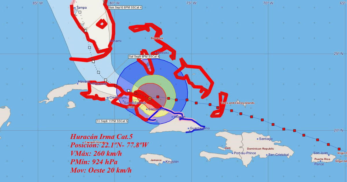
At midnight, the center of intense Hurricane Irma was located by the radar network of the Institute of Meteorology, at 22.1 degrees North latitude and 77.8 degrees West longitude, a position that places it over Cayo Romano, about 68 kilometers southeast. from Cayo Coco, Ciego de Ávila and 170 kilometers east southeast of Caibarién, Villa Clara.
Overnight, Hurricane Irma increased its maximum sustained winds up to 260 kilometers per hour, with higher gusts and a minimum pressure of 924 hectoPascal, so It is again a category five hurricane on the Saffir-Simpson scale. Irma is moving west at 20 kilometers per hour.
As Irma continues its westward movement over the keys north of the provinces of Camagüey and the northern coast of Ciego de Ávila, tropical storm force winds will persist in Holguín and Las Tunas and the southern half from Camagüey to Matanzas where In its northern half the winds will be hurricane-force, between 160 and 190 kilometers per hour, with higher gusts.
On the northern coast of Ciego de Ávila there will be waves between 5.0 – 7.0 meters high, with strong flooding continuing. These conditions will extend towards Sancti Spíritus and Villa Clara, increasing the height of the waves between 7.0 – 9.0 meters and initiating strong flooding, including the Sabana – Camagüey keys.
Overnight, storm surge and flooding conditions will become strong on the north coast of Matanzas, Mayabeque and Havana, including the Havana Malecon.
In the latter the coastal flooding They will begin in the afternoon with strong stages at night and in the early morning. Due to the persistence of strong winds from the southwest region, coastal flooding will occur south of Ciego de Ávila and Sancti Spíritus. On the south coast from Cienfuegos and Matanzas there will be waves between 3.0 and 4.0 meters with light flooding.
In the next 12 to 24 hours, Hurricane Irma will maintain its course close to the west, moving over the northern coast of the central region at night, with fluctuations in its intensity, but it will remain an intense hurricane.
Due to the danger that this organization continues to represent for Cuba, it is recommended to pay attention to the information issued by the Weather Forecast Center of the Institute of Meteorology and the guidelines of the National Civil Defense.
The next Tropical Cyclone Warning about intense Hurricane Irma will be issued at three this morning.
FORECASTING CENTER, INSMET. Date: September 9, 2017. Time: 12:01 am. / M. Llanes and M. A. Hernández
What do you think?
COMMENTFiled in: