
TheTropical Storm Idalia, which has rapidly gained organization and intensity, is in the spotlight of bothCuba likeFlorida. With winds intensifying and a road threatening both regions, weather authorities are on high alert.
HeNational Hurricane Center Miami reported at 4:00 AM CDT thatIdalia It is located approximately 200 km south of the western end ofCuba, with maximum sustained winds of 100 km/h. It is expected thatIdalia become a hurricane later today and a dangerous major hurricane over the northeast of theGulf of Mexico early Wednesday.
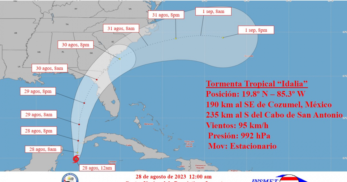
On the other hand, the latest report of theINSMET Forecasting Center, broadcast at 12:00 am on August 28,Idalia has shown a slow and erratic movement, positioning its center further to the southeast. Satellite and radar images reveal an increase in areas of heavy rainfall near the center of circulation, indicating better organization of the system. An oceanographic buoy, located east of the center ofIdalia, has recorded maximum sustained winds of up to 95 km/h and a pressure of 992 hectoPascal.
The authorities have issued aHurricane Warning forPinar del Rio, Cuba. In addition, various surveillance and warnings have been established on the peninsula ofYucatan, Isle of Youth, and parts ofFlorida, including aStorm Surge Watch fromChokoloskee untilIndian Pass inFlorida, covering the bay ofTampa.
During this Sunday, intense rains and thunderstorms have been reported in much ofCuba, related to the circulation ofIdalia. Esmeralda, in the province ofCamaguey, has recorded an accumulated 105 millimeters of rain. It is expected that in the next 12 to 24 hours,Idalia continue to strengthen, with the possibility of becoming a hurricane during Monday.
The provinces ofPinewood of the river, Sagebrush and theIsla de la Juventud Special Municipality They must be especially alert to the persistence and intensity of the rains. In addition, an increase in wind speed is expected in the west of the country, reaching up to 60 km/h in the western end ofPinewood of the river.
The population is urged to pay attention to upcoming warnings and take the necessary precautions. The combination of a dangerousstorm surge and the tide will cause normally dry areas near the coast to flood. The most affected areas will be those with onshore winds, where the storm surge will be accompanied by large and dangerous waves.
NHC Bulletin:
BULLETIN Tropical Storm Idalia - Advisory Number 7 National Hurricane Center Miami, FL 4:00 AM CDT, Monday, August 28, 2023
...IDALIA INTENSIFIES AS IT APPROACHES CUBA... ...INCREASES THE PROBABILITY OF A DANGEROUS FLOOD FROM STORM SURGE AND DANGEROUS WINDS FOR PARTS OF FLORIDA...
INFORMATION SUMMARY AT 4:00 AM CDT...0900 UTC
- Location: 20.1N 85.2W
- Distance: Approximately 200 km south of the western end of Cuba.
- Maximum sustained winds: 100 km/h.
- Current speed: North at 11 km/h.
- Minimum central pressure: 989 mb...29.21 inches.
SURVEILLANCES AND WARNINGS Changes with this notice: None.
Summary of surveillance and warnings in effect:
- Hurricane Warning for Pinar del Río, Cuba.
- Tropical Storm Warning for the Yucatan Peninsula from Tulum to Río Lagartos, including Cozumel, Isla de la Juventud in Cuba and Dry Tortugas in Florida.
- Storm Surge Watch from Chokoloskee to Indian Pass in Florida, including Tampa Bay.
- Hurricane Watch from Englewood to Indian Pass in Florida, including Tampa Bay.
- Tropical Storm Watch from Englewood south to Chokoloskee in Florida and the Florida Keys west of the west end of the Seven Mile Bridge.
DISCUSSION AND FORECAST At 4:00 AM CDT, the center of Tropical Storm Idalia was near latitude 20.1 North, longitude 85.2 West. Idalia is moving north near 11 km/h, and this motion is expected to continue, bringing the center of Idalia near or over western Cuba tonight and over the southeastern tip of the Gulf of Mexico early Tuesday. Idalia is forecast to increase its forward speed and turn north-northeast over the eastern Gulf of Mexico on Tuesday and reach the Florida Gulf Coast on Wednesday.
Maximum sustained winds have increased to near 100 km/h with stronger gusts. Idalia is expected to become a hurricane later today and a dangerous major hurricane over the northeastern Gulf of Mexico early Wednesday.
RISKS AFFECTING LAND Idalia is expected to produce the following rainfall amounts:
- Eastern Yucatan: Additional 1 to 2 inches.
- Western Cuba: 4 to 7 inches, with isolated totals of 10 inches.
- Parts of the west coast of Florida, the Florida Panhandle, southeastern Georgia and the eastern Carolinas: 4 to 8 inches Tuesday through Thursday. Isolated totals of 12 inches possible, primarily near the point of impact in northern Florida.
NEXT NOTICE Next interim advisory at 7:00 AM CDT. Next full advisory at 10:00 AM CDT.
What do you think?
COMMENTFiled in: