
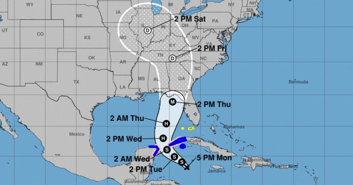
The National Hurricane Center (NHC) warned on Monday that potential cyclone nine will strengthen and reach major hurricane status, named Helene, before impacting the northeast coast of the Gulf of Florida this Thursday.
The second report issued by the NHC indicated that the system will bring dangerous storm surges and devastating winds, primarily affecting the Florida peninsula and the state's west coast.
Hurricane and storm surge warnings are expected to be issued during the night on Monday or the morning on Tuesday for some areas of the affected region, as the risks of severe impacts increase, the NHC emphasized.
He also indicated that residents in these areas should prepare and have their plans in place to mitigate the effects of the hurricane, which would be named Helene.
In its forecast, the NHC also warned of heavy rains expected to impact the western Caribbean, which could lead to flooding and landslides in western Cuba.
Meanwhile, the Cuban Institute of Meteorology (INSMET) issued a warning on Monday for intense rainfall in the western region of the country.
The cause is the potential tropical cyclone forming in the northwest Caribbean Sea, where a large area of low pressure persists, associated with an extensive region of clouds producing showers, rains, and thunderstorms, which has become better organized in the past 12 hours.
The Pinar del Río Forecast Center reported that from Tuesday to Thursday, accumulated rainfall is expected to range between 150 and 200 mm in most of the province, with potential totals exceeding 300 mm in the westernmost areas.
For his part, Cuban meteorologist Raydel Ruisanchez shared on Facebook the projection cone of potential cyclone nine, hinting at the danger it poses to the province of Pinar del Río.
“Winds reaching tropical storm strength from Pinar del Río to Artemisa, including the Isle of Youth, could develop hurricane strength toward the western extremity,” noted the expert.
"Strong swells are expected along the southern coast of the west, including the Isle of Youth," said the meteorologist.
Filed under: