
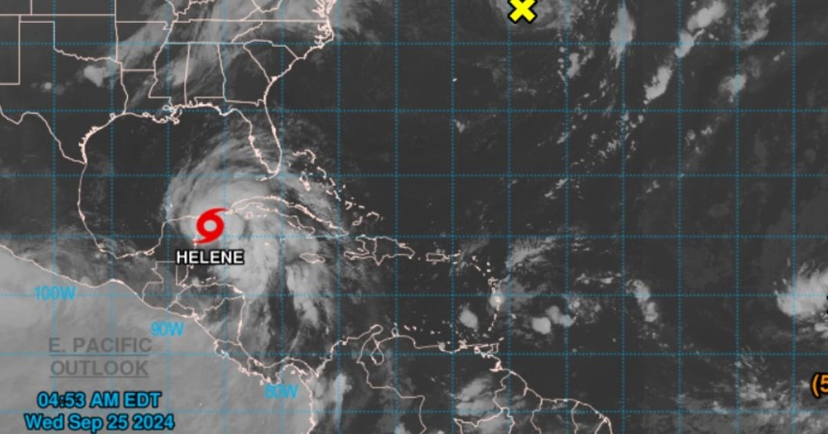
Tropical storm Helene has strengthened a little more as it approaches the northeast coast of the Yucatán Peninsula in Mexico, on its way to the west coast of Florida.
Helene is also bringing heavy rains to the most western area of Cuba, which is located to the right of the meteorological phenomenon and is the most affected by the bands of rain.
At 4:00 a.m. CDT, the storm was located about 75 km east-northeast of Cozumel, Mexico, and about 190 km southwest of Cabo de San Antonio.
Helene is moving northwest at a speed of 15 km/h and has maximum sustained winds of 100 km/h, according to the most recent bulletin from the National Hurricane Center of the U.S.
It is expected to continue its movement to the north over the next few hours, passing near the northeast coast of the Yucatán Peninsula and entering the Gulf of Mexico later today, before making landfall on the west coast of Florida on Thursday night.
It has been forecasted that it could reach the United States as a strong hurricane.
Although Helene is not expected to make landfall in Cuba, it poses significant risks especially for Pinar del Río, which is under a "hurricane alert"; as well as for Artemisa and the Isle of Youth, which are under a "tropical storm advisory."
The mentioned Cuban territories are already being affected by rain and gusts of wind.
In the west of Cuba, storm surges could raise water levels by 2 to 4 feet above normal, especially in the coastal areas of Pinar del Río and Isla de la Juventud.
The heavy rains, with accumulations of up to 12 inches, increase the risk of flash flooding and landslides, particularly in mountainous areas.
In the case of Florida, there is a hurricane warning for the coast of Florida from the Anclote River to Mexico Beach, with hurricane conditions expected on Thursday night.
However, in Florida, the effects of Helene are already being felt on the morning of this Wednesday, with intense rains and strong winds affecting the area. The counties of Miami-Dade, Broward, and Monroe are under a tropical storm warning.
Meteorologists warn of an increasing risk of potentially deadly storm surges and dangerous hurricane-force winds in parts of the northern and northeastern Gulf coast, including areas of the Florida Panhandle and the western coast of the state.
A tropical storm warning is in effect for the Florida Keys, from the 5th Canal Bridge to Ocean Reef, and the west coast up to the Anclote River.
There is also a warning for storm surge in areas like Tampa Bay, where water could reach heights of between 5 and 15 feet, putting the lives of residents in these areas at risk.
Helene is expected to become a hurricane in the coming hours.
What do you think?
COMMENTFiled under: