
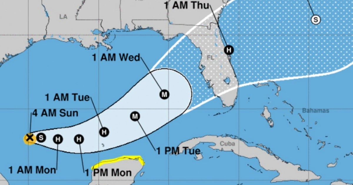
Tropical storm Milton has intensified in recent hours with winds reaching 85 km/h and is slowly but steadily moving towards the west coast of Florida, as revealed by the National Hurricane Center (NHC) in its latest bulletin.
The storm, which at 5:00 a.m. (local time) was located about 355 miles (565 km) west-northwest of Progreso, Mexico, and about 845 miles (1,360 km) west-southwest of Tampa, Florida, is currently moving very slowly at a speed of 5 mph (7 km/h).
Meteorological authorities have warned that Milton could become a hurricane during the night of this Sunday, and it is not ruled out that it could develop into a powerful hurricane as it crosses the central and eastern Gulf of Mexico.
According to the latest data provided by the National Hurricane Center, Milton is expected to continue its movement toward the east-northeast in the next two days, and then accelerate toward the northeast.
The forecast indicates that the storm could reach the west coast of Florida by midweek, bringing intense rains and potential flooding.
The Hurricane Hunter plane from the National Oceanic and Atmospheric Administration (NOAA) is on its way to investigate Tropical Storm Milton, which poses an increasing risk of life-threatening impacts on the Florida west coast.
Current alerts and warnings
A tropical storm warning is in effect for the area between Celestún and Cancún, on the Yucatán Peninsula. This warning means that tropical storm conditions are possible in the region within the next 48 hours. Additionally, parts of the Florida Peninsula, the Keys, and the northwest Bahamas are advised to pay attention to the storm's development, as Milton is expected to strengthen in the coming days.
Associated dangers
Rain: Rainfall accumulations of between 5 and 8 inches are expected in the Florida peninsula and the Keys, with peaks of up to 12 inches in some areas, increasing the risk of flash flooding and urban flooding, as well as river overflows. Rain is also expected in the northern part of the Yucatan Peninsula and western Cuba.
Waves: The swells generated by Milton will begin to affect the southwest coast of the Gulf of Mexico starting today, and will extend to the north and east, potentially creating dangerous rip current conditions and strong waves.
What do you think?
COMMENTFiled under: