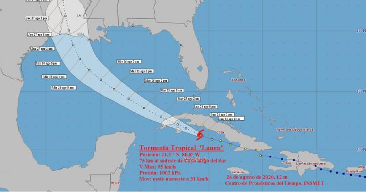
The Civil Defense of Cuba decreed the alarm phase for the western provinces of the archipelago and the special municipality of Isla de la Juventud, according to information from the Forecast Center of the Institute of Meteorology on the evolution and trajectory of tropical storm Laura.
According toInformation note No. 5 of the National Civil Defense General Staff, the meteorological phenomenon is approaching the western region, with a rapid deterioration of the weather conditions in this region in the late afternoon.
The provinces that go into the alarm phase are Matanzas, Mayabeque, Artemisa, Havana and the special municipality of Isla de la Juventud.
The government agency explained that at night the center of Laura will be on the southern coast between Artemisa and Pinar del Río, and the area of influence will occupy the entire western region with strong and intense rains and sustained winds between 65 and 80 km. /h with higher gusts.
Recent reports from the Forecast Center of the Cuban Institute of Meteorology (INSMET)They located Tropical Storm Laura approaching the Gulf of Batabanó. Likewise, the winds are expected to gradually increase and blow with tropical storm force from midday, in the center of the country, with sustained speeds between 65 and 80 kilometers per hour, with higher gusts and from the end of the afternoon and the night in the western provinces.
Strong swells with light coastal flooding will continue on the northern coast from Ciego de Ávila to Villa Clara, while on the southern coast from Ciego de Ávila to Cienfuegos light to moderate coastal flooding will occur in the next few hours.
At noon, the center of Laura was estimated at 21.2 degrees North latitude and 80.8 degrees West longitude, a position that places it about 75 kilometers southeast of Cayo Largo del Sur and 185 kilometers southeast of Punta Gorda, Zapata Peninsula. , Matanzas.
The phenomenon has continued its rapid movement to the west-northwest, somewhat decreasing its translation speed, which is now 31 kilometers per hour, while its maximum winds are 95 kilometers per hour, with higher gusts, with a central pressure of 1002 hectoPascal.
The forecasts indicate that, in the next few hours, the storm may gain somewhat more organization and intensity, because its center will move over the warm waters of the Gulf of Batabanó.
The effects of the meteorological phenomenon are already evident in the territories of the eastern part of the archipelago. In Santiago de Cuba, Lauracaused the fall of several trees and damage to the electrical service due to broken poles.
The phenomenon left the municipalities of Segundo Frente, Contramaestre, Guamá and Tercer Frente completely without electricity. However, it has not left considerable volumes of water for the territory's reservoirs, although the Hydraulic Resources delegation points out that there is an increase of about 4,413 million cubic meters in the Northeast, the main system that supplies the city.
On the other hand,Laura caused the collapse of the Yao Nave bridge, in the province of Granma, leaving about 30 mountain communities of the San Pablo de Yao Popular Council in Buey Arriba, Sierra Maestra, isolated. The collapse was caused by flooding rivers and heavy rains.
In the province of Guantánamo, the storm also caused damage,mainly in housing and electrical infrastructure. Local authorities reported damage to homes and state buildings, collapse of banana plantations in Yateritas, the largest producing area in the region, and damage to the electrical system of almost all the municipalities of the easternmost province of Cuba.
What do you think?
COMMENTFiled in: