Satellite images demonstrate the power of Hurricane Beryl, which has been upgraded to a Category 4 on the Saffir-Simpson scale since this Sunday.
"Incredible satellite images of the intense Category 4 Hurricane Beryl and its impressive, yet dangerous, eye currently approaching the Windward Islands," wrote on the X Weather/ Meteo World account, alongside a video showing the size of the hurricane.
This Sunday, a reconnaissance plane from the National Hurricane Center (NHC) of the United States found that Beryl has strengthened, presenting a condition of "extreme danger" due to its maximum winds of 130 mph.
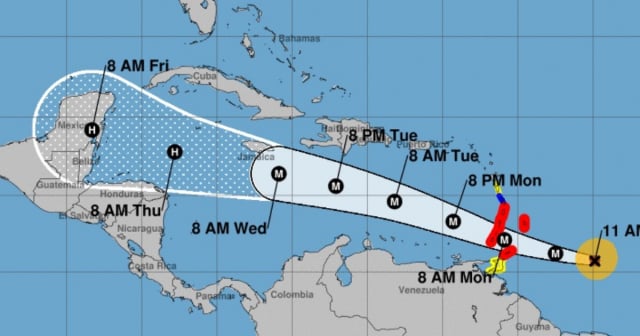
According to the trajectory presented by the National Hurricane Center (NHC), Beryl is staying away from the coasts of Cuba, while the Windward Islands, especially St. Vincent, the Grenadines, and Grenada, will bear the brunt of the powerful weather event from early Monday morning.
Meteorologists agree that this cyclonic system is the earliest Category 4 hurricane ever recorded in the Atlantic, surpassing Dennis in 2005 by a week.
"Without a doubt, Beryl will try to reach Category 5 status in the next few hours as it continues to intensify. An incredibly historic storm in almost every way. Residents in the southern Leeward Islands must speed up their preparations and complete them in the next few hours. The monster is coming," wrote American meteorologist Michael Ferragamo in X.
What is your opinion?
COMMENTFiled under: