
Hurricane Milton has intensified its strength to category 3 on the Saffir-Simpson scale and is shaping up as a potentially deadly threat to the west coast of Florida.
The weather event will also affect the Yucatán Peninsula, where it may bring heavy rains and high waves. The recent report does not mention the effects it may have in western Cuba, but due to its proximity, it is advisable to keep an eye on it.
The National Hurricane Center (NHC) has warned about the severe risks of storm surges, torrential rains, and destructive winds in these regions.
In the Gulf of Mexico, Milton is expected to strengthen even more. It has a major hurricane intensity, and all indications are that it will make landfall in Florida midweek.
This dangerous cyclone arrives at a critical moment, just after the devastating passage of Hurricane Helene through the southeastern United States, which left nearly 200 dead.
Federal authorities are facing criticism for the delayed response in assisting victims, raising further concerns about preparedness for this new cyclone.
The communities affected by Helene are still recovering, which makes Milton a delicate challenge for the emergency teams.
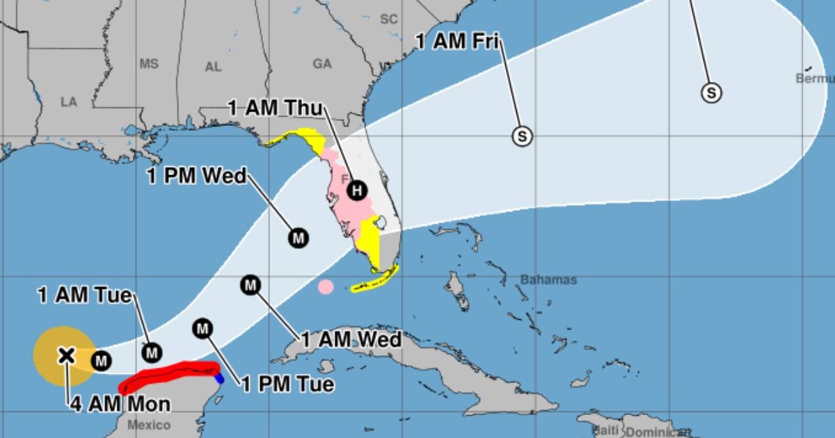
Warnings and evacuations due to Hurricane Milton in Florida:
State authorities have issued mandatory evacuation orders in vulnerable areas such as Pasco County and Anna Maria Island, near Tampa.
Other counties have recommended that those residing in coastal buildings prepare for voluntary evacuations.
Residents are urged not to wait until the last minute and to evacuate the high-risk areas as soon as the orders are issued.
- Hurricane watchIssued for the Gulf Coast of Florida from Chokoloskee to the mouth of the Suwannee River, including Tampa Bay and the Florida Keys (Dry Tortugas).
- Monitoring of storm surgeOn the Gulf coast of Florida, from Flamingo north to the Suwannee River, including Charlotte Harbor and Tampa Bay.
- Tropical storm watchFrom Flamingo south to Chokoloskee and along the Gulf Coast of Florida, north to the Suwannee River up to Indian Pass, in addition to the Florida Keys (Lower, Middle, and Upper Keys).
The water level could rise between 8 to 12 feet in areas near Tampa Bay and the Anclote River, Florida. In Charlotte Harbor and other coastal areas of Florida, they could also face increases in the level of between 5 to 10 feet, which could cause serious flooding in the most vulnerable areas.
Cyclone surge can flood normally dry coastal areas. It will affect a large part of the Gulf coast with rip currents that could be deadly.
Current conditions and forecast about Hurricane Milton:
The exact track of the hurricane is still unclear, but meteorologists warn that on Monday it could undergo rapid intensification, which would make Hurricane Milton an even greater threat.
- It is located 195 miles (310 km) northwest of Progreso, Mexico, and 750 miles (1,210 km) west-southwest of Tampa, Florida.
- Maximum sustained winds: 120 mph (195 km/h)
- Minimum central pressure: 972 mb (28.71 inches).
- Current movement: East-southeast at 8 mph (13 km/h).
The western areas of Florida are already starting to feel the indirect effects of the hurricane with heavy rains since this Sunday.
These rains will continue to increase in intensity as the hurricane approaches, generating possible flash floods, with an elevated risk of dangerous storm surges along the west coast.
What do you think?
COMMENTFiled under: