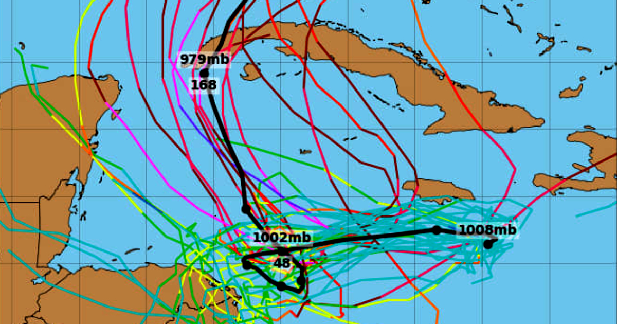
The National Hurricane Center of the United States (NHC) is monitoring a new tropical wave in the central Caribbean that could develop into tropical cyclone "Sara" in the coming days.
If it materializes, this would be the eighteenth named tropical storm of the active 2024 hurricane season in the Atlantic. Although marked by uncertainty, forecast models indicate a moderate probability that its path will impact Cuba.
According to the latest report from the NHC, this tropical wave is causing “disorganized showers and thunderstorms” over the central Caribbean Sea, currently located southeast of Jamaica.
The system, driven by an area of low pressure, is moving west at a speed of between nine and 18 kilometers per hour, with a trajectory that leads it toward the mainland of Central America.
The NHC indicated that "the environmental conditions appear favorable for development," increasing the likelihood that the system will evolve into a tropical depression in the next two to three days.
If this happens, and the cyclonic phenomenon gains enough organization and strength, the system would be named "Sara" and would become the next tropical cyclone on this year's list, following storms such as Alberto, Beryl, Chris, and Rafael.
Possible trajectory of Sara and its impact on the Caribbean
Although it is still early to determine a definitive path, initial projections suggest that the system could move westward, potentially impacting areas such as Jamaica and Hispaniola, where residents should remain vigilant for weather advisories.
As the system strengthens and moves through the western Caribbean, the NHC anticipates that it may change course to the northwest early next week, directing its path toward areas near Honduras, Belize, and the Yucatán Peninsula in Mexico.
Although the likelihood of Sara making landfall in Cuba is currently low, the NHC emphasizes that forecasts may change in the coming days, and meteorologists are keeping a close watch on the system.
Anticipated Climate Impacts in the Caribbean and Possible Effects on Cuba
The influence of this tropical wave is already being felt in the central Caribbean, where heavy rains and thunderstorms are occurring, especially near Hispaniola.
As the low-pressure area moves westward, the NHC anticipates that atmospheric conditions will become more unstable, with an increase in winds across Cuba, particularly in the northwestern region of the island, where a shift to northerly and northeasterly winds is expected beginning Thursday.
By Friday, the low-pressure system in the southwest Caribbean is expected to cause rough seas and strong winds in the area until Sunday night. This phenomenon will further intensify due to a stationary front located northeast of Puerto Rico, which will generate significant wave activity affecting the region.
If tropical cyclone Sara materializes, its effects could include heavy rains, winds ranging from moderate to strong, and an increase in wave heights, impacting maritime activities and creating potential coastal flooding in northwest Cuba and other areas of the western Caribbean.
The NHC estimates that there is a 60% chance of this system becoming a cyclone in the next 48 hours, a figure that increases to 90% within a week. Meteorological authorities are urging residents of the region to follow updates on the forecast and to prepare for possible events related to the formation of this tropical cyclone in the Caribbean.
Filed under: