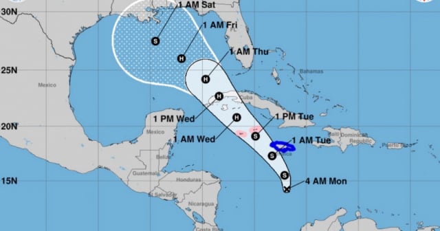
The National Hurricane Center (NHC) has issued a bulletin alerting about Tropical Depression Eighteen, which continues to move through the Caribbean.
At 10:00 AM EST, the system was located approximately 310 km south of Kingston, Jamaica, and 645 km southeast of Grand Cayman.
Maximum sustained winds reach 55 km/h, moving north at 15 km/h with a central pressure of 1003 mb.
The NHC specified in its latest bulletin that the Cuban government has issued a Hurricane Watch for the provinces of Pinar del Río, Artemisa, Havana, Mayabeque, Matanzas, and the Isle of Youth.
Additionally, a Tropical Storm Watch has been issued for the provinces of Villa Clara, Cienfuegos, Sancti Spíritus, Ciego de Ávila, Camagüey, and Las Tunas.
These precautionary measures aim to anticipate potential hurricane and tropical storm conditions in the next 48 hours.
The forecast indicates that Tropical Depression Eighteen will continue moving north and then turn northwest, approaching Jamaica tonight, passing near the Cayman Islands on Tuesday, and heading towards Cuba on Wednesday.
This morning, a hurricane-hunting plane flew over the area of low pressure in the Central Caribbean, where it found a well-defined circulation center.
Continuous strengthening of the system is expected, which could evolve into a tropical storm later today and reach hurricane status by the middle of the week.
Authorities are warning about potential significant impacts in Cuba.
Hurricane conditions are expected in the western part of the country and on the Isle of Youth on Wednesday, while the central region of the island may experience tropical storm conditions.
The rains associated with the system could be intense, with accumulations ranging from 75 to 150 mm and localized maxima of up to 225 mm, which could trigger flooding and landslides in vulnerable areas.
Additionally, there is a warning about the possibility of cyclonic swells that could raise water levels by 0.6 to 1.2 meters along the southern coast of Pinar del Río and the Isle of Youth.
An increase in wave activity is also expected to impact much of the western Caribbean in the coming days.
Key messages for tropical depression
Hurricane conditions are expected in the Cayman Islands on Tuesday and could occur in parts of Cuba early Wednesday, where hurricane warnings and watches are in effect. There is a risk of dangerous impacts from hurricane-force winds and storm surge in the Cayman Islands and portions of western Cuba. Tropical storm conditions are anticipated in Jamaica tonight.
Interests in the Florida Keys should closely monitor this system, as tropical storms may need to be observed for parts of these areas later today.
The system is expected to enter the Gulf of Mexico by the end of this week, but given the significant uncertainties in long-range forecasting and intensity, it is too early to determine what impacts may occur, if any. Residents in that area should regularly monitor forecast updates.
The system will bring heavy rainfall to parts of the western Caribbean, including Jamaica and areas of Cuba, until the middle of the week. Flooding and landslides are possible in these regions. The heavy precipitation will extend northward into Florida and adjacent areas of the southeastern United States by midweek.
The population in areas under watch and advisory is advised to continue monitoring information and to complete the necessary preparations to protect life and property.
What do you think?
COMMENTFiled under:
