
Related videos:
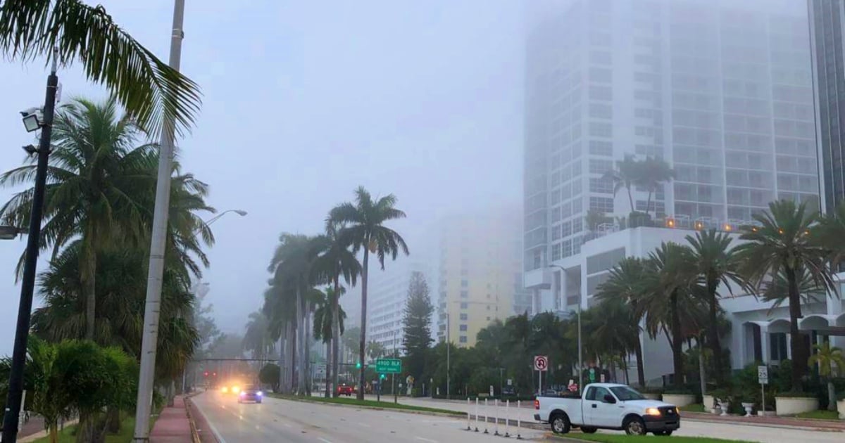
A dense layer of fog is covering several areas of South Florida this Tuesday, primarily affecting inland sections of Miami-Dade and Broward counties, and significantly reducing visibility for drivers during the early hours of the day.
The phenomenon, caused by calm wind conditions, has kept the fog nearly stationary in the same areas, extending its duration beyond dawn.
This situation led the National Weather Service (NWS) to issue a special fog advisory, initially in effect until 9:00 a.m.
Current Conditions and Climate Evolution
According to the forecasts -released by Telemundo 51- this Tuesday will mark the beginning of a more stable and warmer weather pattern in the southern part of the peninsula.
Despite the presence of morning fog, it is expected that the gradual warming throughout the day, along with the influence of the sea breeze, may lead to some showers in inland areas.
However, the dominant dry air mass will significantly limit the development of widespread storms.
Today's atmospheric tranquility contrasts with what is expected in the coming days.
Starting Wednesday, moderate winds will return, intensifying on Thursday with gusts that could reach up to 30 miles per hour.
This situation will increase the risk of rip currents along Florida's east coast, posing a danger to swimmers and boaters.
Extended forecast:
Tuesday: Morning fog and a chance of isolated showers inland. Maximum temperature around 86°F (30°C).
Wednesday: Mostly sunny skies with a gentle breeze. Minimum of 72°F (22°C) and a maximum of 85°F (29°C).
Thursday: Strong winds, with gusts up to 30 mph. Minimum of 75°F (24°C) and maximum of 84°F (29°C).
Recommendations from the NWS in the face of fog conditions
In the presence of dense fog and limited visibility, the National Weather Service has shared a series of recommendations for drivers, aimed at preventing accidents on the road:
-Slow down and allow extra time to reach your destination.
Use low beams, not high beams, to avoid glare that can impair vision. Turn on the fog lights if your vehicle is equipped with them.
Maintain a safe distance from the vehicle in front of you to anticipate sudden brakes or unexpected changes in traffic.
-Follow the lines on the pavement to stay in your lane.
If visibility is extremely low:
Turn on the emergency lights.
-Pull over in a safe place, such as the parking lot of a nearby establishment.
If there is no safe location available, move as far to the right of the road as possible, turn off all lights except for the hazard lights, engage the emergency brake, and take your foot off the brake pedal to prevent the rear lights from staying on and to avoid being struck by other vehicles.
Frequently asked questions about fog in South Florida
Which areas are most affected by fog in South Florida?
The areas most affected by the fog are the interior sectors of Miami-Dade and Broward counties, where visibility has significantly decreased during the early hours of the day. The fog is more pronounced in areas further from the coast due to calm wind conditions that have kept the phenomenon stationary.
What are the recommendations for driving in dense fog?
The National Weather Service recommends reducing speed and using low beams to avoid glare. It is also advised to maintain a safe distance from the vehicle ahead and to follow the pavement markings to stay in the lane. In cases of extremely low visibility, it is important to turn on hazard lights and pull over to a safe location.
How will the climate evolve in South Florida after the fog?
After the morning fog, the weather in southern Florida is expected to be more stable and warm, with a gradual warming throughout the day. However, some showers may be recorded in inland areas. Starting Wednesday, moderate winds will return and will intensify on Thursday, increasing the risk of rip currents along Florida's east coast.
What measures should be taken in response to the risk of rip currents?
It is essential for swimmers and boaters to be aware of the sea conditions and follow the recommendations of local authorities. Rip currents can be dangerous, so it is advisable to swim near a lifeguard station and not enter the water if conditions are unfavorable.
Filed under: