
The National Hurricane Center (NHC) announced the formation of the possible tropical cyclone number nine of the season in the Caribbean Sea.
The agency issued alerts and warnings for tropical storms for parts of western Cuba and the northeast of the Yucatán Peninsula in Mexico.
It is expected that the system will become a hurricane on Wednesday morning.
At 11:00 am on this Monday, the system was located 130 miles south-southwest of Grand Cayman, and 350 miles southeast of the westernmost point of Cuba. It was moving north at 6 mph with maximum sustained winds of 30 mph.
According to the report, it is forecasted that the disturbance will strengthen and be close to becoming a hurricane when it reaches the Caribbean Sea on Tuesday night.
"Tropical storm conditions are expected over portions of western Cuba and the northeastern coast of the Yucatán Peninsula with possible hurricane conditions," the note details.
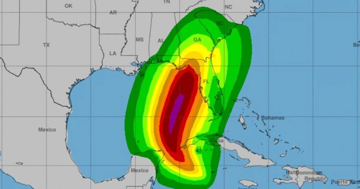
The system is expected to intensify as it moves north over the eastern Gulf of Mexico, and it could become a major hurricane when it reaches the Northeastern Gulf Coast on Thursday.
There is an increasing risk of storm surges and damaging hurricane-force winds along portions of the northern and northeastern Gulf coast, including the Florida Panhandle and parts of Florida's west coast.
The potential tropical cyclone nine will bring heavy rains to areas of the western Caribbean that may cause flooding and possible landslides in western Cuba.
The NHC issued alerts and tropical storm warnings for parts of western Cuba, including Pinar del Río, Artemisa, and the Isle of Youth.
POSSIBLE DAMAGES FOR CUBA
Regarding the rains, NHC experts indicate in the report that the potential tropical cyclone may produce total accumulations of 4 to 8 inches over western Cuba and the Cayman Islands, with isolated totals of around 12 inches. Heavy rains will extend into the southeastern United States from Wednesday through Friday, with a risk of thunderstorms and river flooding.
Cyclonic surges could raise water levels by 2 to 4 feet above normal levels along the southern coast of Pinar del Río and the Isle of Youth.
In relation to the winds, hurricane conditions may develop within the monitored areas early Wednesday. Tropical storm conditions are expected starting Tuesday.
What do you think?
COMMENTFiled under: