
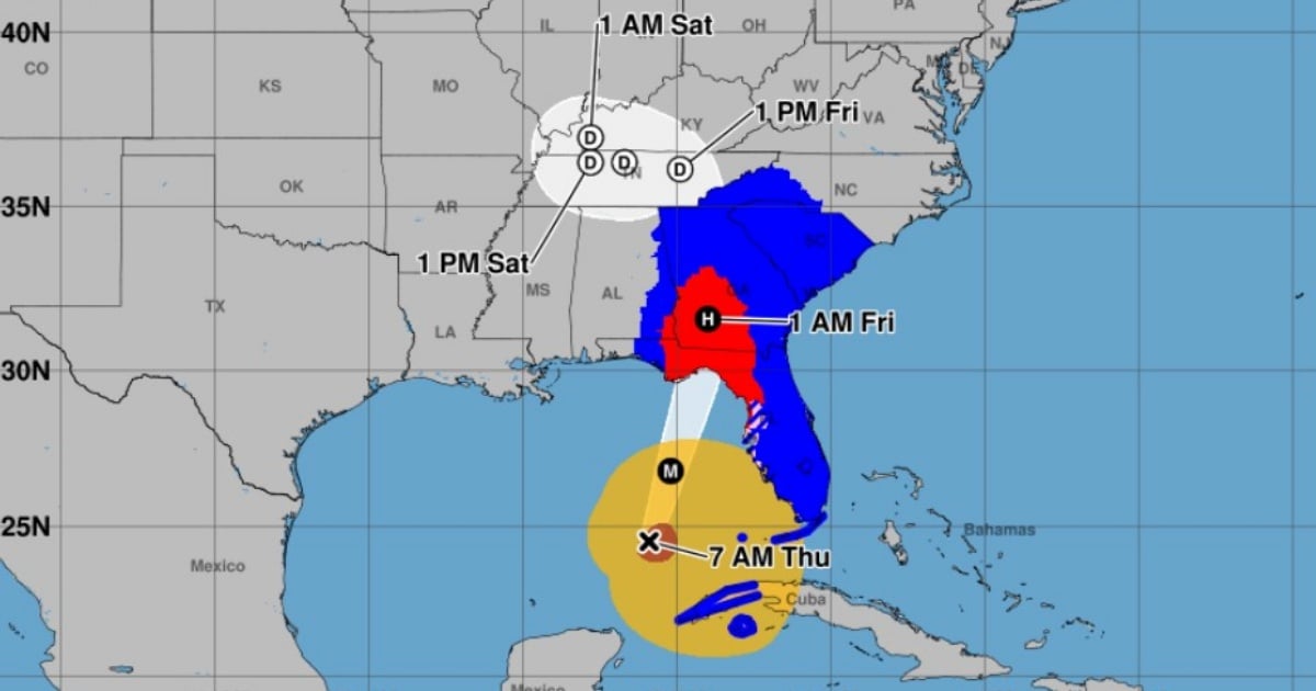
Helene has continued to strengthen and is now a Category 2 hurricane, according to the National Hurricane Center in its intermediate bulletin at 7:00 a.m. (local time).
The meteorological phenomenon now has maximum sustained winds of 155 km/h and is moving to the north-northeast at 19 km/h.
At 7:00 a.m., the eye of Helene was located about 515 kilometers southwest of Tampa and about 585 kilometers from
Apalachicola. Previously, the NHC warned that the hurricane could reach Category 4 before making landfall on Thursday night on the northern coast of Florida, likely in the area known as Big Bend.
In the early morning of this Thursday, the hurricane was unleashing heavy rains and strong winds over areas of southern Florida and Cuba.
The NHC has warned that Helene is a massive tropical system with the potential to cause severe damage in Florida, where it is expected to trigger torrential rains, destructive winds, and dangerous storm surges.
Experts indicate that there is an increasing risk of potentially deadly storm surges and damaging hurricane winds along parts of the northern and northeastern Gulf Coast, including the Panhandle of Florida and parts of the west coast of Florida.
However, in southern Florida, the impact of the phenomenon will also be felt, which is accompanied by a wide band of rain and winds.
Current alerts and warnings
Cyclone surge warning: It is in effect from Playa Mexico to Flamingo, covering Tampa Bay and Charlotte Harbor. This means that dangerous flooding is expected due to rising waters in the next 36 hours.
Hurricane warning: In effect from Río Anclote to Playa México, which means hurricane conditions are expected within the next 36 hours.
Tropical storm warning: In effect for the Florida Keys, including the Dry Tortugas, as well as from Flamingo to the Anclote River and several areas of western Florida and northern Cuba (including the Cuban provinces of Artemisa, Pinar del Río, and the Isle of Youth).
Expected impacts
Cyclonic surge: Helene is expected to cause dangerous flooding in coastal areas due to rising sea levels. The most affected areas could experience water level increases of between 5 and 20 feet, depending on the location. In southern Pinar del Río, Cuba, water levels could rise between 2 and 4 feet.
Winds: It is forecasted that the areas under hurricane warnings will experience destructive winds of up to 150 km/h, with gusts that could reach higher speeds. Tropical storm-force winds are already affecting the Florida Keys and are expected to extend northward along the Gulf coast.
Intense rains: The precipitation associated with Helene could cause accumulations of between 6 and 18 inches in the southeast United States, with a risk of flash flooding and urban flooding. In Cuba, between 4 and 12 inches of rain are expected, which could also result in significant flooding.
Tornado risk: The risk of tornadoes will increase this afternoon and is expected to mainly affect northern Florida, southeastern Georgia, and the Carolinas.
Local authorities have issued mandatory evacuation orders in several vulnerable areas of Florida. The population in the affected zones is advised to follow the instructions of local officials and quickly complete any preparations to protect lives and property.
Conditions will deteriorate quickly as Helene approaches the coast, so it is crucial that evacuations and preparations are completed before the end of the day.
Tropical storm Helene formed in the northwest Caribbean Sea on September 24, with forecasts indicating rapid intensification into a hurricane.
What do you think?
COMMENTFiled under: