
The Cuban Institute of Meteorology (Insmet) issued a tropical cyclone warning on the afternoon of this Monday, regarding the intensification of Hurricane Milton, which has become a powerful and dangerous category 5, the highest level on the Saffir-Simpson scale, as it moves over the Gulf of Mexico and approaches Florida.
With this perspective, Insmet forecasts that "winds from the south to the southwest will be generated starting this afternoon, with speeds of between 15 and 30 kilometers per hour in the western region of Cuba."
They also report that "tomorrow there will be an increase in the strength of sustained winds from Pinar del Río to Mayabeque, with speeds between 25 and 40 kilometers per hour and up to 50 kilometers per hour, with higher gusts in Pinar del Río starting in the late afternoon."
The entity announced the occurrence, starting tonight, of waves on the southern coast of the western region, which will gradually increase to swells in the south of the Isle of Youth and Pinar del Río during the early hours of Tuesday.
There is a probability of coastal flooding starting tomorrow on the southern coast from Pinar del Río to Mayabeque, including the Isle of Youth. "The storm surges and coastal flooding will begin on Wednesday along the northwestern coast, including the Havana seawall," they indicate.
For the rest of this Monday, "the conditions will be favorable for rain throughout the country, mainly in the interior and northern coast during the afternoon."
"The extensive circulation of Hurricane Milton and the feeding bands associated with this system will keep instability in the west with showers and rain starting late tonight," they comment.
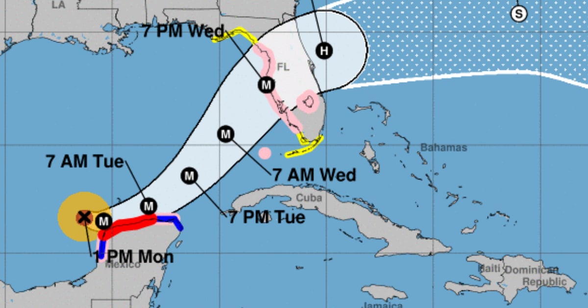
Finally, they point out that this hurricane "is maintaining a slow movement toward the east-southeast over the Gulf of Mexico."
"During the next 12 to 24 hours, this hurricane will maintain a similar movement, tilting its trajectory to the east, passing very close to or over the Yucatan Peninsula. Currently, forecasting models indicate that tomorrow the hurricane will tilt its course to the northeast, increasing its forward speed to approach the west coast of the Florida Peninsula in the evening-night of Wednesday," they note.
Due to its current position and future trajectory through the Gulf of Mexico towards the Florida Peninsula, the Forecast Center will maintain close monitoring of its evolution over the next few days.
What do you think?
COMMENTFiled under: