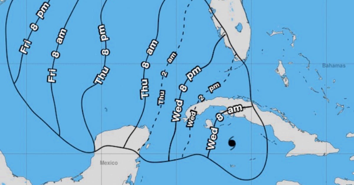
The National Major State of Civil Defense declared the Cyclonic Alarm Phase at 6 AM this Wednesday for eight Cuban provinces and the Isle of Youth due to the imminent approach of Hurricane Rafael, which recently reached Category 2 on the Saffir-Simpson scale.
In its information note number 4, dated 11 p.m. on November 5, the Civil Defense indicated that the decision was made in anticipation of worsening weather conditions, "with rain, showers, and thunderstorms expected to be strong and locally intense across the entire western and central regions of the country, with accumulations between 100 and 200 millimeters in 24 hours."
The Cyclonic Alarm phase is in effect since 6:00 a.m. today for the provinces of Villa Clara, Sancti Spíritus, Cienfuegos, Matanzas, Mayabeque, Havana, Artemisa, Pinar del Río, and the special municipality of Isla de la Juventud.
The remaining seven provinces—Guantánamo, Santiago de Cuba, Holguín, Granma, Las Tunas, Camagüey, and Ciego de Ávila—are currently in the Informative Phase.
Civil Defense also warned of strong swells along the central and western southern coast, with moderate to severe coastal flooding in the southern provinces of Sancti Spíritus, Cienfuegos, Matanzas, Mayabeque, Artemisa, and Pinar del Río, as well as in the Isle of Youth and the Canarreos archipelago.
"The population is advised to stay informed about the evolution of this system through national, provincial, and municipal media, as well as the official profiles on social networks, and to strictly adhere to the instructions provided by local authorities and Civil Defense," concluded the state entity.
The Meteorological Institute (INSMET) warned in its 6:00 a.m. bulletin on Wednesday that the weather situation in Cuba will rapidly deteriorate in the coming hours, a fact already confirmed by meteorological radars.
During the early morning hours, heavy rains, showers, and thunderstorms have been reported in the eastern and central regions, with an expected increase in the western area.
In the morning, winds will be from the east to southeast in the west and center, with speeds ranging between 50 and 65 km/h.
Starting in the afternoon, winds will shift to the southeast-south, with speeds between 95 and 110 km/h and higher gusts. In areas near the center of this tropical system, winds will reach hurricane strength as they move across the western region.
Strong swells are expected along the central and western southern coast, with moderate to severe coastal flooding in the southern areas of Sancti Spíritus, Cienfuegos, Matanzas, Mayabeque, Artemisa, and Pinar del Río, as well as in the Isle of Youth and the Canarreos archipelago.
At 7:00 a.m., the eye of the hurricane was located 140 kilometers east-southeast of the Isle of Youth and 260 kilometers south-southeast of Havana, Cuba, with maximum sustained winds of 160 km/h, moving northwest at 22 km/h.
Several Cuban meteorologists have made various posts on social media urging the population in the western part of the country to prepare. It is expected that Rafael will make landfall at some point between Artemisa and Pinar del Río.
What do you think?
COMMENTFiled under: