
Related videos:
Imelda, which became a tropical storm this Sunday, continues its path northward, bringing heavy rain to the Bahamas and eastern provinces of Cuba, with potential impacts on the east coast of the United States in the coming days, according to the National Hurricane Center (NHC).
Although the center of Imelda will not make landfall in the United States, its effects will reach the coastal strip of the southeast.
According to the latest bulletin from the NHC, accumulations of 1 to 2 inches (25 to 50 mm) of rain are expected from northeastern Florida to North Carolina, with possible peaks of up to 4 inches (100 mm) in localized areas.
These rains could lead to minor flooding in urban areas and isolated overflow of streams or secondary rivers, especially in areas with saturated soils or inadequate infrastructure.
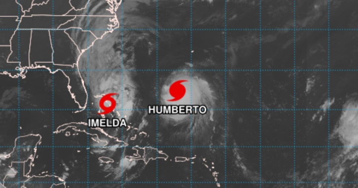
According to the 5:00 a.m. (Eastern Time) bulletin on Monday, September 29, the system was located about 60 miles (approximately 100 km) south of Great Abaco Island and about 295 miles (475 km) southeast of Cape Canaveral, Florida.
It has maximum sustained winds of 45 miles per hour (75 km/h) and is moving north at a speed of 8 mph (13 km/h).
Imelda is bringing rainfall accumulations of between 2 and 4 inches (50 to 100 mm) to eastern Cuba, and 4 to 8 inches (100 to 200 mm) to the northwest Bahamas through Tuesday, with a risk of urban flooding, sudden floods, and landslides in elevated areas of eastern Cuba.
It is also expected that the system will indirectly affect the American continent: along the coast of the Carolinas, the NHC forecasts rainfall of 1 to 2 inches (25 to 50 mm), with peaks of up to 4 inches (100 mm), which could cause minor flooding and rises in small rivers.
Additionally, the system could strengthen in the next 24 to 36 hours and become a hurricane on Tuesday, which would increase the effects on coastal areas of the southeastern U.S. due to swell, rip currents, and minor storm surges.
Projected trajectory: From the western Caribbean to the Atlantic
At 5:00 a.m. EDT on Monday, the center of Imelda was located at a latitude of 25.5° North and a longitude of 77.1° West.
The forecast indicates that the system will continue moving north throughout the day, and on Tuesday, it will make a sharp turn toward the east-northeast, moving away from the southeastern United States and into the western Atlantic.
However, the storm's broad area of influence— with tropical force winds extending up to 175 miles (280 km) from the center, mainly to the east of the system—means that its effects will be felt beyond the central zone of its path, especially in the Bahamas, the Atlantic coast of the Caribbean, and the southeastern United States.
Current alerts and recent changes
The government of the Bahamas has discontinued tropical storm warnings for central Bahamas and some areas in the northwest, including New Providence, the Berry Islands, and Andros Island.
However, a tropical storm warning remains in effect for: Eleuthera, the Abaco Islands, Grand Bahama Island, and the surrounding cays in the northwest of the archipelago.
A tropical storm warning means that dangerous conditions are expected on land within the next 12 hours, including intense wind gusts, heavy rainfall, and elevated sea levels.
The accumulated rainfall in the northwest of the archipelago could range from 4 to 8 inches (100 to 200 mm) by Tuesday, which poses a significant risk of urban and flash floods, especially in low-lying areas without adequate drainage systems.
A storm surge of 1 to 3 feet (30 to 90 cm) above ground level is also expected, which could worsen coastal impact.
Eastern Cuba
Imelda's outer bands are delivering between 2 and 4 inches (50 to 100 mm) of rain over eastern Cuba.
Local authorities have warned about the possibility of landslides in mountainous areas, as well as flash floods in densely populated urban areas.
Waves, swells, and dangerous undertow
One of the broadest and most dangerous effects of Imelda will be the high waves and strong rip currents.
The NHC warns that both Imelda and Hurricane Humberto -also active in the Atlantic- are generating swells that are already affecting the Bahamas and will extend along the East Coast of the U.S. in the coming days.
These swells can generate:
- Potentially lethal rip currents, especially dangerous for swimmers, surfers, and small boats.
-Significant swell, which will complicate maritime conditions from Florida to the Carolinas.
Additionally, minor coastal flooding is possible in areas where winds are blowing onshore.
Among the areas most vulnerable to flooding is the coastline between:
-The boundary of Volusia/Brevard counties (Florida).
-The South Santee River (South Carolina).
There, the water could rise between 1 and 2 feet (30 to 60 cm) above ground level, especially during high tide cycles.
Bermuda is also in sight
As Imelda moves to the east-northeast, the Bermuda archipelago could experience indirect effects from the system.
Between Wednesday and Thursday, rainfall is predicted to be between 50 and 100 mm with rough seas, although there will be no direct impact from the center of the storm.
An active hurricane season that is still far from over
Imelda is part of a particularly active 2025 hurricane season in the Atlantic, as warned by NOAA in May.
To date, several named storms have formed, including: Andrea in June; Gabrielle, a category 4 hurricane that impacted the eastern part of Bermuda; and Humberto, which is currently active in the central tropical Atlantic.
The season officially runs from June 1 to November 30, but the current atmospheric and oceanic conditions—warmer sea surface temperatures and reduced wind shear—continue to favor above-average activity.
In its August update, NOAA projected:
-13 to 18 named storms (winds greater than 39 mph / 63 km/h)
-5 to 9 hurricanes (winds >74 mph / 119 km/h)
-2 to 5 hurricanes of high intensity (category 3 or higher, >111 mph / 179 km/h)
Imelda could become the next system to reach hurricane status if it continues to strengthen as expected.
Recommendations: Continuous monitoring and caution
Although Imelda is not making direct landfall in the United States, its effects are already being felt in the Caribbean and the Atlantic coast. The National Hurricane Center advises residents and visitors in the affected areas:
-Monitor the official bulletins issued by the NHC and local meteorological services.
-Avoid entering the sea in areas with strong waves or a risk of rip currents.
-Pay attention to possible flood alerts in urban areas or areas prone to runoff.
Do not underestimate the indirect risk of storms that are far from the coast.
The evolution of Imelda in the next 24 to 48 hours will be crucial in determining its final category and the level of impact on the region.
Frequently Asked Questions about Tropical Storm Imelda and Its Potential Effects
What path will tropical storm Imelda take?
Imelda is heading north, initially affecting the Bahamas and the eastern provinces of Cuba. It is expected to make a turn towards the east-northeast, moving away from the southeast of the United States and entering the western Atlantic, according to the National Hurricane Center (NHC).
What are the possible impacts of Storm Imelda on the East Coast of the United States?
Although the center of Imelda will not make landfall in the United States, rainfall of 1 to 2 inches is expected from northeastern Florida to North Carolina, with possible peaks of up to 4 inches. These conditions could lead to minor flooding and overflowing of small rivers.
What precautions should residents of the areas affected by Imelda take?
Residents should monitor the official bulletins from the NHC and local weather services. It is advised to avoid entering the sea in areas with strong waves, pay attention to potential flood alerts, and not underestimate the indirect risks posed by the storm.
Filed under: