
Related videos:
Hurricane Melissa continues to gain strength over the central Caribbean Sea and has intensified to a category 4 on the Saffir-Simpson scale, with maximum sustained winds of 240 kilometers per hour and a minimum central pressure of 926 millibars, according to the National Hurricane Center (NHC) in the report issued at 2:00 AM this Monday.
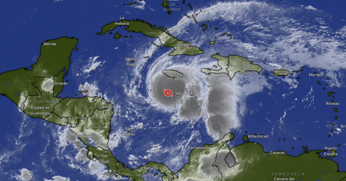
The center of the system was located about 210 kilometers southwest of Kingston, Jamaica, and about 505 kilometers southwest of Guantánamo, Cuba. Melissa is slowly moving west at a speed of 7 kilometers per hour, and it is expected that throughout the day it will turn north and then northeast, approaching Jamaica during the night and to the east of Cuba on Tuesday night.
Meteorological authorities predict that Melissa will maintain its Category 4 status over the next few hours and will continue to be a powerful hurricane when it directly impacts Jamaica, where extremely dangerous conditions are expected, including hurricane-force winds, destructive storm surges, and heavy rainfall that could lead to catastrophic flooding and landslides in mountainous and coastal areas.
The NHC warned that accumulated rainfall could range from 380 to 760 millimeters (15 to 30 inches) in various areas of Jamaica, with isolated spots possibly exceeding one meter of rain. These intense rains will also impact Haiti and the south of the Dominican Republic, where accumulations of between 200 and 400 millimeters are expected, posing an extreme risk of flash floods and mudslides.
In the eastern part of Cuba, particularly in the provinces of Granma, Santiago de Cuba, Guantánamo, and Holguín —under hurricane warning— accumulated rainfall is expected to range between 250 and 380 millimeters, with maximums reaching up to 500 millimeters in mountainous areas. These conditions could lead to river overflows, landslides, and significant coastal flooding along the southeastern coastline.
The phenomenon will also trigger a dangerous storm surge along the southern coast of Jamaica, with waves that could reach heights of three to four meters, especially in areas located east of the point of impact. In Cuba, the Institute of Meteorology (INSMET) warned that the rising sea levels and strong waves could also severely affect coastal communities in Santiago de Cuba, Guantánamo, and low-lying areas of Granma.
According to the forecast from the National Hurricane Center, the core of Melissa will move over or very near Jamaica between the night of this Monday and the early hours of Tuesday, will traverse eastern Cuba on Tuesday night, and will continue its trajectory towards the northeast, crossing the Bahamas starting Wednesday. Although some fluctuation in intensity is expected, the American agency anticipates that the hurricane will maintain its major system status at least until it passes Cuba.
The government of Jamaica has issued preventive evacuation alerts in several coastal communities in the south of the country and has set up temporary shelters in anticipation of the imminent arrival of the hurricane. In Cuba, Civil Defense authorities declared the cyclone alarm phase in the eastern provinces, urging the population to reinforce roofs, protect homes, and stay informed through official updates.
Hurricane Melissa is also generating strong waves in the Caribbean Sea, with swells reaching the coasts of Haiti, the Dominican Republic, eastern Cuba, and the Cayman Islands. In the coming days, the dangerous sea conditions will extend to the southeast and central Bahamas, and subsequently to Bermuda.
The National Hurricane Center reiterated that the most dangerous effects of Melissa will be concentrated in Jamaica and eastern Cuba over the next 48 hours, with particular attention to the risk of flash flooding and landslides in mountainous areas.
In its statement, the U.S. agency emphasized that preparations to protect lives and property must be completed in Jamaica and quickly advance in Cuba, where winds are expected to intensify starting Tuesday afternoon.
CiberCuba maintains constant monitoring of the evolution of hurricane Melissa and the alerts issued by the meteorological services of the Caribbean and the National Hurricane Center, providing updates on its trajectory, intensity, and impacts in the region.
Filed under: