
Related videos:
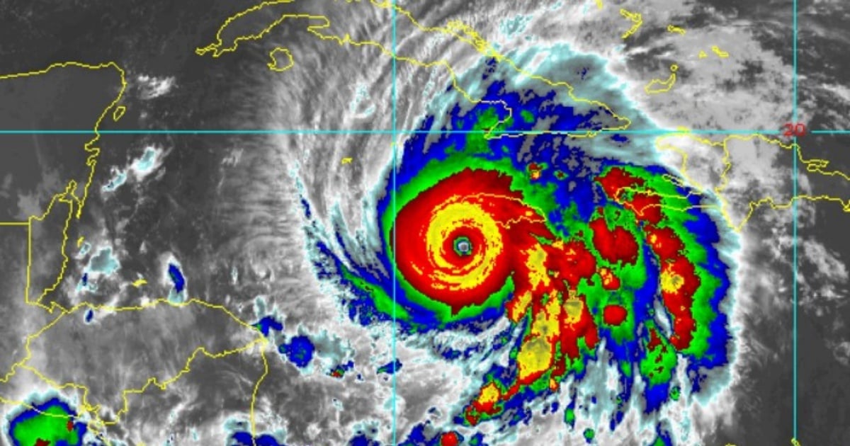
The hurricane Melissa, which remains at a category 5 - the highest intensity level on the Saffir-Simpson scale- has slightly increased its translational speed and has slightly altered its course in the last three hours.
This is indicated in the latest bulletin from the National Hurricane Center (NHC), which also noted that Melissa is maintaining sustained winds of 175 mph (280 km/h).
At 5:00 a.m. (EDT) this Tuesday, its central pressure was at 901 mb, a clear indication of the extreme intensity of this system.
However, compared to the 2:00 a.m. bulletin, Melissa has slightly changed its course: it is now moving to the north-northeast (25 degrees) instead of north-northwest as reported earlier.
This change in trajectory implies a closer proximity to Jamaica: the hurricane is now located just 115 miles (180 km) from Kingston, which is 20 miles closer than in the previous report.
Additionally, the powerful weather phenomenon has begun to accelerate its movement, albeit very slightly.
During the early morning, it doubled its translation speed, increasing from 2 mph (3.22 km/h) to 5 mph (8.05 km/h), indicating that the system is entering a phase of more dynamic movement, which will take it over Jamaica today and since the early morning over eastern Cuba.
Catastrophic conditions for Jamaica: The impact is imminent
This morning, the NHC warned: “Melissa is expected to make landfall as an extremely dangerous hurricane over Jamaica.”
Melissa is already battering Jamaica with tropical storm winds.
Kingston airport reported sustained winds of 63 km/h and gusts of 93 km/h, while Montego Bay reached gusts of 91 km/h.
However, these values are merely the preamble to the main event.
The NHC warns that hurricane-force winds will begin this morning. In mountainous or elevated areas, gusts could be up to 30% stronger, causing what the bulletin describes as a "total structural failure" in vulnerable buildings, particularly in windward areas.
Cyclone surge: The southern coasts of Jamaica are expected to experience a storm surge of 9 to 13 feet (up to 4 meters) above ground level, accompanied by destructive wave activity. On the northwest coast, including Montego Bay, the sea could rise by 2 to 4 feet.
Rainfall: The precipitation forecast is alarming. The NHC anticipates between 15 and 30 inches of rain (38 to 76 cm) on the island, with local maxima of up to 40 inches (more than a meter). This could lead to catastrophic flash flooding and widespread landslides in urban and rural areas.
Maximum alert for Cuba: The eastern provinces are on high alert
The provinces of Granma, Santiago de Cuba, Guantánamo, and Holguín are under hurricane warning
While Las Tunas is under a tropical storm warning.
The NHC urges that preparations be completed to protect lives and property in Cuba before conditions worsen later tonight.
Rainfall:
10 to 20 inches of rain are forecasted for eastern Cuba, with peaks of up to 25 inches in specific areas. The rainfall will be accompanied by flash flooding and potentially deadly landslides.
Cyclonic swell:
The southeastern coast of Cuba could experience a storm surge of up to 11 feet (3.3 meters) above normal levels, particularly to the east of the point where the eye of the hurricane makes landfall. The combination with powerful waves exacerbates coastal risks.
The impact will extend to the Bahamas, Haiti, and possibly Bermuda
In Haiti, already under tropical storm warning, rain and flooding are expected from today until tomorrow.
In the southeast and central Bahamas, hurricane conditions are forecasted starting Wednesday, with rainfall between 5 to 10 inches and the possibility of storm surges up to 4 to 6 feet.
Newsletter update: possible watch for Bermuda For the first time, the 5:00 a.m. bulletin includes a direct warning to interests in Bermuda.
Although an official watch has not yet been issued, the NHC warns that it may be necessary later today or during the night, depending on how the trajectory evolves.
Extreme maritime conditions: swell and surf throughout the western Caribbean
The swells generated by Melissa are already being felt in Hispaniola, Jamaica, eastern Cuba, and the Cayman Islands, and they will extend to the Bahamas, Turks and Caicos, and Bermuda in the coming days.
These waves and rip currents could be potentially deadly, warns the NHC.
The agency advises the population to stay away from coastal areas and to remain informed through official sources, as the evolution of the system remains active and dynamic.
Summary: An unprecedented hurricane threatens with a direct impact
Melissa represents one of the most severe cyclonic threats in the Caribbean region in recent years.
Its combination of extreme winds, historic rainfall, a direct path over densely populated islands, and increasing translational speed makes it a phenomenon of very high risk.
The international community and regional meteorological services are maintaining constant vigilance, while local authorities in Jamaica, Cuba, Haiti, and the Bahamas implement emergency plans, evacuations, and utility shutdowns.
Filed under: