
Related videos:
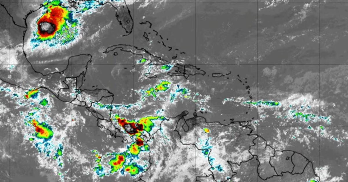
The Cuban meteorologist José Rubiera warned this Wednesday about the formation of Arthur, the first tropical storm of the 2026 Atlantic hurricane season, a system that threatens severe flooding in several states of the southern United States.
In a detailed analysis published on his YouTube channel, Dr. José Rubiera explained that the system originated as a low-pressure area that crossed land and, upon entering the Gulf of Mexico, encountered exceptionally warm waters ranging from 30 to 32 degrees Celsius, which fueled its rapid organization. "There are temperatures of 30, 31, even 32 degrees at the sea surface."
"Therefore, it is very warm water, with a lot of energy, and that characteristic of having great energy in the ocean caused convection to erupt," the expert pointed out.
At 11:00 a.m. Eastern Time, the center of Arthur was located about 90 miles south of Galveston, Texas, with maximum sustained winds of 75 km/h and gusts up to 100 km/h, moving northeast at approximately 15 km/h.
Rubiera described Arthur as a short-lived system, forecasting that it would make landfall on the night of Wednesday in the southwest of Texas or southern Louisiana.
"It is going to have a short lifespan. It will make landfall soon, likely over the southwest of Texas or the southwest and south of the state of Louisiana," he specified.
However, the meteorologist emphasized that the real danger lies not in the winds but in the precipitation. "Rain is the important factor. Local flooding is the most dangerous aspect regarding the impacts of this system," he warned.
The National Hurricane Center projected rainfall accumulations ranging from 13 to 25 centimeters, with isolated totals of up to 50 centimeters in some areas.
The areas at the highest risk of flooding include Texas, Louisiana, Mississippi, Alabama, Georgia, and the northernmost part of Florida.
Flash flood warnings were issued for the Houston metropolitan area, and the National Weather Service identified a moderate risk of heavy rainfall in areas including New Orleans and Mobile.
A warning was also issued for a storm surge of two to four feet from Port Bolivar, Texas, to Morgan City, Louisiana, as well as for possible isolated tornadoes along the Gulf Coast.
For Cuba, Rubiera predicted little activity: "In Cuba, little rain overall, but in the afternoon, there may be some showers, some rain, and possibly a thunderstorm in the central and eastern parts."
The meteorologist also warned about a possible scenario after it moves over land. "When it reaches the Atlantic, it could be a different story because it will encounter the Gulf Stream, warm water also along the eastern coast of the United States, and it could potentially develop in the Atlantic," he explained, although he clarified that it's still too early to know for sure.
Arthur's training comes in the context of a 2026 hurricane season that forecasts predicted to be less active than usual, influenced by the El Niño phenomenon.
NOAA estimated between eight and 14 named storms for the entire season, while the Cuban Meteorology Institute predicted a 40% chance that at least one hurricane would impact the island.
"It remains to be seen what will happen when Arthur moves through the United States and heads out to the Atlantic coast. In the Atlantic, what will happen? Will it regenerate? We don't know yet," concluded Rubiera.
Filed under: