
Related videos:
An experimental assessment published this Monday by NASA estimates that approximately 58,870 buildings were likely damaged or destroyed in Venezuela as a result of the devastating double earthquake on June 24, 2026.
The analysis was conducted by researchers Corey Scher and Jamon Van Den Hoek from Oregon State University, using data from the radar of the Sentinel-1 satellite from the European Copernicus program, and represents the first satellite-scale tool available to guide on-ground response teams.
The main earthquake, with a magnitude of 7.5, was preceded just 39 seconds earlier by a tremor of magnitude 7.2, with epicenters in Yaracuy state, near San Felipe and Yumare, in the north-central part of the country.
The tremors spread strongly along the central coast and even reached the metropolitan area of Caracas, in what is considered the strongest earthquake recorded in Venezuela since 1900.
To create the damage map, researchers compared two satellite images taken after the earthquake—one on June 24 over the epicentral area and another on June 25 over Greater Caracas, including Petare and Antímano—with a database of 65 reference images captured during the year prior to the disaster.
The technique used, known as coherence change detection, measures the stability of the surface between two passes of the satellite: a sudden loss of coherence indicates abrupt changes, such as the collapse of structures.
According to the methodology, a building is classified as damaged when at least 50% of its footprint falls on the coherence loss map, with a threshold calibrated to keep the false alarm rate at or below 1% in areas with mild shaking.
Approximately 75% of the assessed dry territory was successfully covered by satellite images; the areas with no data correspond to regions where the two radar passes did not overlap, in addition to open waters and sparsely built land to the south.
The most severe damage was concentrated in the central coastal strip and the Caracas corridor, a pattern consistent with the intensity recorded by the earthquake.
Data from the European program Copernicus also identified 434 completely destroyed buildings, with 30% of the constructions in Catia la Mar collapsed and 6% affected in La Guaira.
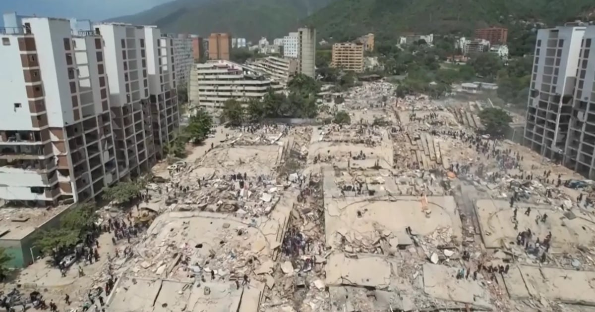
In Caracas, the neighborhoods of Los Palos Grandes, San Bernardino, and Altamira experienced the most severe damage, including the collapse of the 14-story Petunia residential building and the Bancaribe building, among other structures.
NASA itself warns that this is a preliminary evaluation and not validated in the field: "it should be read as an indicator, not as a census building by building," the document states.
The human toll of the disaster is catastrophic: the Venezuelan government confirmed on Monday 1,719 dead and 5,034 injured, while the UN estimated that there could be up to 50,000 missing persons and a total of 6.76 million affected.
The United States Geological Survey (USGS) issued a Red Alert—its highest level—and estimated a 42% probability that the final number of victims could be between 10,000 and 100,000.
The United Nations Development Programme (UNDP) estimated the direct damages at $6.7 billion, equivalent to 6% of Venezuela's GDP, with a total potential impact ranging from $10.05 billion to $20.1 billion.
Filed under: