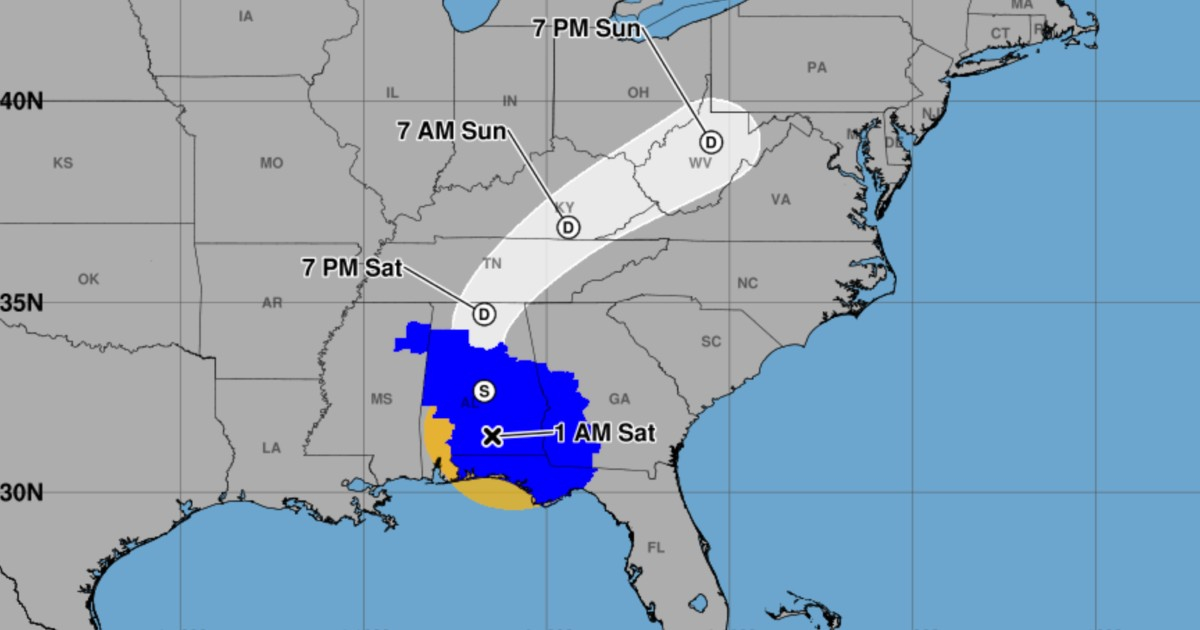
Isaiah is now a post-tropical cyclone, though it still has sustained maximum winds of 100 km/h (65 mph) and continues to pose a threat with heavy rain, flooding, and strong gusts in the southeastern United States, confirmed the National Hurricane Center (NHC).
The new classification appears in the intermediate advisory number 14A from the NHC, valid at 1:00 a.m. CDT on Saturday, October 10, 2026 (2:00 a.m. Miami; 06:00 UTC). This represents a change from the previous advisory, which still described Isaías as a hurricane and anticipated its transition to a post-tropical system.
At that time, the center of Isaías was located over southern Alabama, about 130 kilometers north-northeast of Pensacola, Florida, and 90 kilometers south-southwest of Montgomery, Alabama. It was moving north at 31 km/h, with an estimated central pressure of 1,000 millibars. Tropical storm-force winds extended up to 260 kilometers from the center.
The NHC anticipates a gradual weakening as the system crosses Alabama and moves into the Tennessee Valley over the weekend. However, it warned that strong gusts may continue inland even after the post-tropical transition.
Hurricane warnings have been lifted, but alerts remain in place in Florida
The update includes a reduction in coastal warnings. The NHC canceled the hurricane warning west of the border between Alabama and Florida and replaced it with a tropical storm warning that was in effect from the east of that border to the line separating Bay and Gulf counties in Florida. It also lifted the storm surge warning west of the line between Santa Rosa and Okaloosa counties.
Nevertheless, a storm surge warning remains in effect from the Santa Rosa-Okaloosa division to the Suwannee River in Florida, as well as a tropical storm warning from the eastern Alabama-Florida border to the Aucilla River.
According to the forecast, the surge could raise water levels between 0.6 and 1.2 meters (2 to 4 feet) above ground level in coastal areas ranging from Santa Rosa-Okaloosa to Suwannee, if the peak of the surge coincides with high tide. The NHC emphasizes that coastal flooding can endanger lives and that conditions can vary significantly depending on the location along the coast and the tide.
Risk of flooding, tornadoes, and hazardous wave conditions
The expected rainfall until the end of the weekend will reach between 100 and 200 millimeters (4 to 8 inches) in southern Alabama, the Panhandle, the Big Bend region of Florida, and southwestern Georgia. In particularly intense bands of rain, localized totals of up to 380 millimeters (15 inches) could be recorded, especially in areas of the Panhandle and Big Bend.
In other areas of the southeastern United States, precipitation is forecasted to range from 50 to 125 millimeters, with localized accumulations exceeding that amount. The agency warns of possible flash flooding, urban flooding, and river flooding, as well as landslides in the southern Appalachian region.
The bulletin also indicates that the risk of tornadoes will continue on Saturday in parts of the Florida Panhandle, Georgia, and the Carolinas. Additionally, the swell associated with Isaias is affecting areas along the Gulf coasts of the United States and Mexico, as well as western Cuba, with a risk of dangerous rip currents.
This is a new phase of the system after Isaías previously diminished to a category 1 hurricane after making landfall in Florida. The post-tropical condition means that it is no longer classified as a tropical cyclone, not that its dangerous effects have disappeared.
Authorities recommend that residents in the areas under warning follow the evacuation and protection instructions from local services. The NHC announced its next full advisory for 4:00 a.m. CDT on Saturday, so data and alerts may change. The information in this article corresponds to the intermediate advisory 14A, at 06:00 UTC on October 10.
Related videos:
Filed under: