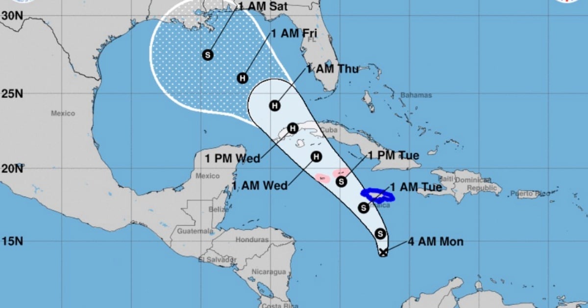
Tropical Cyclone 18 continues to organize in the western Caribbean and is expected to become a tropical storm in the coming hours. As it advances, it is likely to make landfall in western Cuba as a hurricane, possibly on Wednesday, according to the latest bulletin from the National Hurricane Center (NHC) of the United States.
The phenomenon is moving north at 11 km/h, with maximum sustained winds of 55 km/h and a minimum central pressure of 1004 mb.
At 4:00 AM EST today, the system was located approximately 420 km south of Kingston, Jamaica, and 730 km southeast of the Cayman Islands.
The Potential Tropical Cyclone 18 is expected to develop into a tropical storm in the Caribbean this Monday and intensify into a hurricane by Tuesday night.
The system is expected to move northwest throughout today and in the coming days, getting closer to Jamaica by the end of the day.
The latest trajectory forecast for the phenomenon indicates that it will make landfall at some point in western Cuba in the afternoon of November 6.
Meteorological authorities have warned of the possibility of accumulated rainfall ranging from 3 to 6 inches, with some localized areas potentially receiving up to 9 inches.
These conditions would increase the risk of flooding and landslides in Cuba, particularly in areas already vulnerable due to their topography or infrastructure.
The swells generated by the system will also affect the western Caribbean, which could include the coasts of Cuba, resulting in dangerous waves and potential minor coastal flooding.
Given the potential for the cyclone to develop into a tropical storm and even reach hurricane strength as it moves northwest, the population in Cuba and the Florida Keys is advised to stay alert for updates and to follow the guidance of local authorities.
Heavy rains may extend northward, also affecting parts of Florida and the southeastern United States in the coming days.
At six in the evening this Sunday, Cuba's Civil Defense declared the informative phase for the provinces from Pinar del Río to Camagüey, including the special municipality of Isla de la Juventud.
According to the state agency, the provinces of Camagüey, Ciego de Ávila, Sancti Spíritus, Cienfuegos, Villa Clara, Matanzas, Mayabeque, La Habana, Artemisa, Pinar del Río, and the Special Municipality of Isla de la Juventud are moving to this phase due to the organization of the low-pressure area in the southern part of the western Caribbean Sea.
What do you think?
VIEW COMMENTS (1)Filed under: