
Related videos:
The National Hurricane Center (NHC) of the United States reported on Friday afternoon that the Tropical Storm Melissa continues to reorganize over the Caribbean Sea and could significantly intensify in the coming hours.
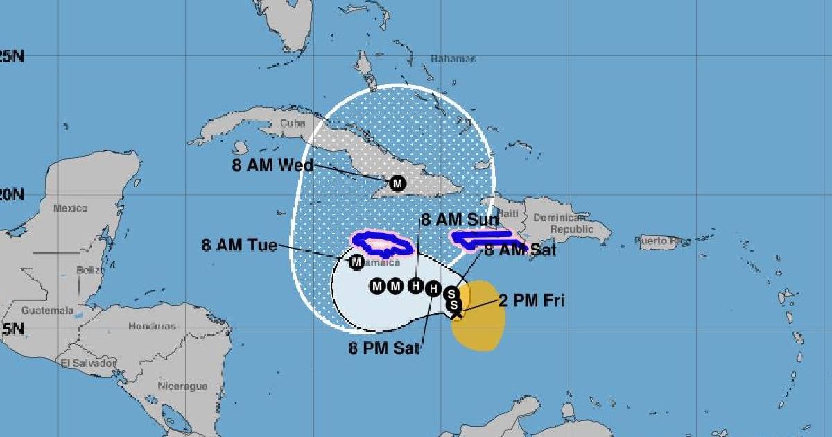
According to the official report at 2:00 p.m. (Eastern Time), the center of the system was located at 15.6° north latitude and 74.4° west longitude, approximately 370 kilometers southeast of Kingston (Jamaica) and 400 kilometers southwest of Port-au-Prince (Haiti).
Melissa has maximum sustained winds of 95 km/h and a minimum central pressure of 997 millibars, as it moves slowly towards the east-southeast at just 4 km/h.
“Melissa is reorganizing and is in a position to substantially intensify in the coming days,” noted the NHC in its bulletin.
"Catastrophic rainfall and flash floods that threaten life in southern Haiti and Jamaica are expected over the weekend," he emphasized.
The NHC forecast indicates that Melissa could reach hurricane status on Saturday and become a major hurricane (category 3 or higher) before Sunday, driven by the high temperatures of the Caribbean Sea and a favorable atmospheric environment.
In its projected path, the center of the storm will slowly move northward and then westward over the weekend, passing near or south of Jamaica at the beginning of next week and possibly near eastern Cuba between Tuesday and Wednesday.
The NHC warned that, although there is still uncertainty about the exact path, the eastern region of Cuba should remain vigilant regarding the progress of the system, given its potential for strengthening and causing heavy rains and severe flooding.
The NHC warned that Jamaica could receive a hurricane advisory in the coming hours if the rapid strengthening of the system is confirmed.
Melissa could leave accumulations of 250 to 500 millimeters of rain (10 to 20 inches) in southern Haiti and eastern Jamaica, with even greater amounts in mountainous areas.
In the rest of Haiti, the Dominican Republic, and southern Cuba, accumulations could reach between 150 and 300 millimeters.
The NHC warns about flash flooding, landslides, and severe damage from rising waters in urban and rural areas. “Conditions could be catastrophic in southern Haiti,” cautions the official report.
The Institute of Meteorology of Cuba (INSMET) is closely monitoring the system, which could pose a potential threat to the provinces of Guantánamo, Santiago de Cuba, Granma, and Holguín if it continues on its northwest trajectory.
The National Major Staff of Civil Defense declared this Friday the Informative Phase in six provinces in the central and eastern parts of the country due to the possibility of deteriorating weather conditions starting this weekend.
Emergency agencies urged the public to stay alert for official reports and to avoid spreading unverified information.
Filed under: