The tropical storm Melissa continues to gain strength in the western Caribbean and could become a major hurricane (Category 3 or higher) before approaching eastern Cuba in the middle of next week, according to a report this Friday from the National Hurricane Center (NHC) of the United States.
The deputy director of the NHC, Jamie Rhome, provided a video update where he specified that, according to the latest models, Melissa could make landfall between the provinces of Granma and Santiago de Cuba, although “the track cone has shifted slightly to the east,” which opens the possibility that the center of the system could pass outside of Cuban territory.
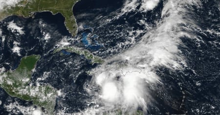
The NHC's bulletin number 12, issued this Friday at 5:00 a.m. (Eastern Time), warns that the system maintains sustained maximum winds of 75 km/h and a minimum central pressure of 1003 millibars, as it slowly moves toward the northern Caribbean Sea.
The nearly stationary movement of Melissa is generating torrential rains over Jamaica and Haiti, with the risk of catastrophic flooding and landslides.
"The heavy rains will result in flash flooding that poses a threat to life and numerous landslides in the southwest of Haiti and Jamaica," warned the NHC.
The provinces of Guantánamo, Santiago de Cuba, Granma, and Holguín would be the most vulnerable.
The NHC indicated that the high temperatures of the Caribbean Sea and low wind shear favor a rapid strengthening of the storm in the next 48 to 72 hours, making it likely to become a major hurricane before approaching Cuba.
If this evolution is confirmed, Melissa would be the second major hurricane to directly threaten the island during the current Atlantic hurricane season.
The Forecast Center of the Cuban Institute of Meteorology (INSMET) confirmed that it is closely monitoring the system, whose central region was located last night at 16.0° North latitude and 75.5° West longitude, about 260 kilometers south-southeast of Kingston, Jamaica.
The agency warned that Melissa poses “a potential danger to the geographic area”, especially to the south of the Greater Antilles, where it could gain organization and intensity in the coming days.
Meanwhile, the weather in Cuba remains under the influence of high surface pressure, with an upper-level trough that has caused rainfall in the eastern and central parts of the country.
On the northern coast of Guantánamo, heavy rainfall was recorded, with a maximum accumulation of 45 millimeters in the locality of Jamal over the past 12 hours. In the rest of the national territory, the rainfall has been scarce.
INSMET also reported that no tropical cyclonic development is forecast in the rest of the Atlantic, the Caribbean Sea, or the Gulf of Mexico over the next 24 hours.
Filed under: