
Related videos:
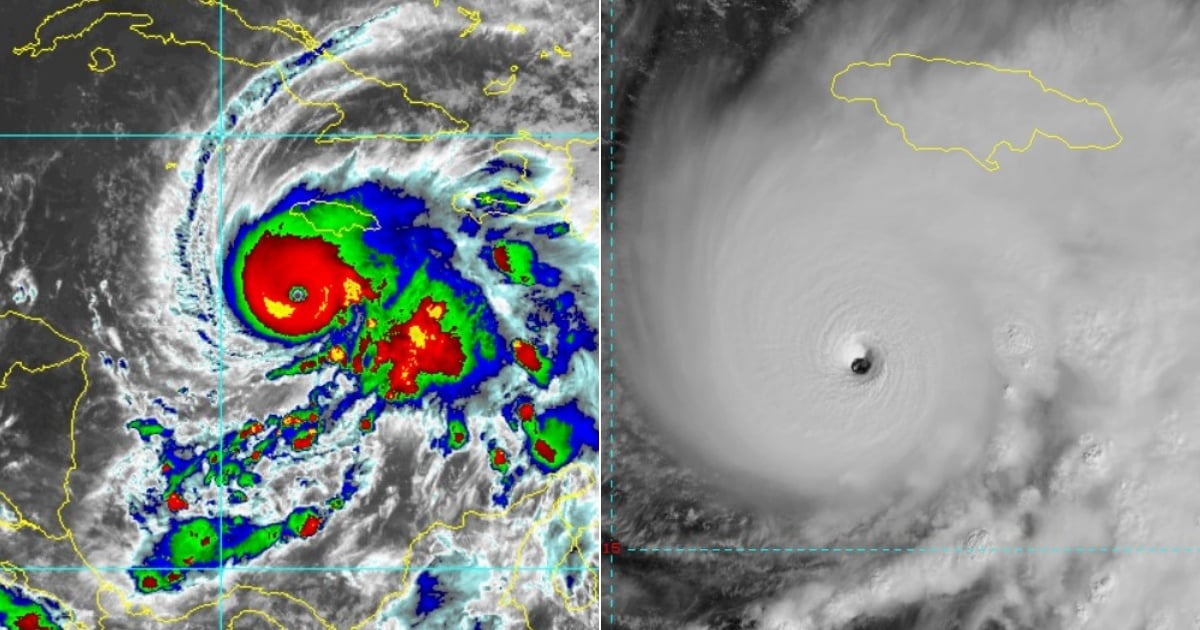
Hurricane Melissa has intensified in strength, reaching maximum sustained winds of 270 km/h, according to the latest bulletin from the National Hurricane Center (NHC), issued at 11:00 a.m. (Eastern Time) this Monday.
This new figure -10 km/h higher than the previous report- confirms its status as a category 5 hurricane, the highest level on the Saffir-Simpson scale, and presents a very high-risk scenario for Cuba, as well as for Jamaica, which will be its first stop in the Caribbean.
“Melissa is a category 5 hurricane […] It is expected to reach the southeast of Cuba as a very powerful hurricane,” the NHC warned.
The storm, currently located about 530 km southwest of Guantánamo, is slowly moving west at just 6 km/h, but a turn to the north is expected tonight that could take its core directly over Jamaica and subsequently to eastern Cuba on Tuesday night.
Cuba: Active warnings and potential for severe impact
The bulletin includes a hurricane warning for the Cuban provinces of Granma, Santiago de Cuba, Guantánamo, and Holguín, indicating that hurricane conditions are expected in those areas within the next 36 hours.
In addition, Las Tunas is under a tropical storm warning, and other regions such as the Bahamas and the Turks and Caicos Islands are on alert.
"Tropical storm conditions are expected to begin in eastern Cuba on Tuesday. Hurricane conditions are expected to start in the hurricane watch area by Tuesday night."
Cuban authorities have been urged to expedite preparations to protect life and property, particularly in coastal and mountainous areas, where the impact of winds could be amplified.
Catastrophic winds and extreme rainfall
With a minimum central pressure of 908 mb, Melissa has reached an unusual intensity even among the most destructive hurricanes in the region.
The NHC warned that hurricane-force winds extend up to 45 km from the center of the cyclone, while tropical storm-force winds cover a radius of up to 315 km, thus affecting a wide area of the western Caribbean.
For Cuba, the main danger is not limited to the winds.
A torrential rain episode is expected in the eastern part of the country, with between 15 and 20 inches (38-50 cm) of rainfall, and the potential for even higher local accumulations.
This could lead to catastrophic flash floods and landslides, especially in mountainous areas like the Sierra Maestra.
"The NHC warned that total rainfall of 15 to 20 inches is expected, with locally higher amounts, which will result in potentially catastrophic and deadly flash floods accompanied by numerous landslides."
Cyclonic surge on the horizon: up to 11 feet high
Another significant risk is the storm surge, which could severely impact the southern coast of eastern Cuba. The forecast predicts that sea levels could rise between 7 and 11 feet (2 to 3.3 meters) above normal, accompanied by destructive waves.
"There is a possibility of a significant storm surge along the southeast coast of Cuba […] It will be accompanied by large and destructive waves," warns the report.
These effects would add to the already complex situation of flooding caused by rains and wave action, putting not only coastal infrastructures at risk but entire communities as well.
Trajectory and Perspectives
Although Melissa's eye is expected to first make landfall in Jamaica tonight, the report makes it clear that Cuba will be its next high-impact target: "the center of Melissa will move […] over southeastern Cuba Tuesday night."
From there, a northeast movement is expected over the Bahamas on Wednesday.
The slow current movement of the cyclone complicates forecasts and exacerbates the threat, as it prolongs the exposure of affected regions to heavy rainfall, strong winds, and destructive waves.
Conclusions and recommendations
Hurricane Melissa represents an extreme threat to eastern Cuba, with the potential to cause widespread structural damage, loss of life, and mass displacements.
Authorities must expedite evacuation plans in vulnerable areas, and the public should remain vigilant and rely solely on official sources such as the Institute of Meteorology of Cuba and the National Hurricane Center of the U.S.
The upcoming bulletins will be crucial for determining the hurricane's path and final intensity upon making landfall in Cuba.
The island has faced devastating hurricanes in the past, but the current magnitude of Melissa, with sustained winds of 270 km/h, places it in an exceptionally dangerous category.
Filed under: