
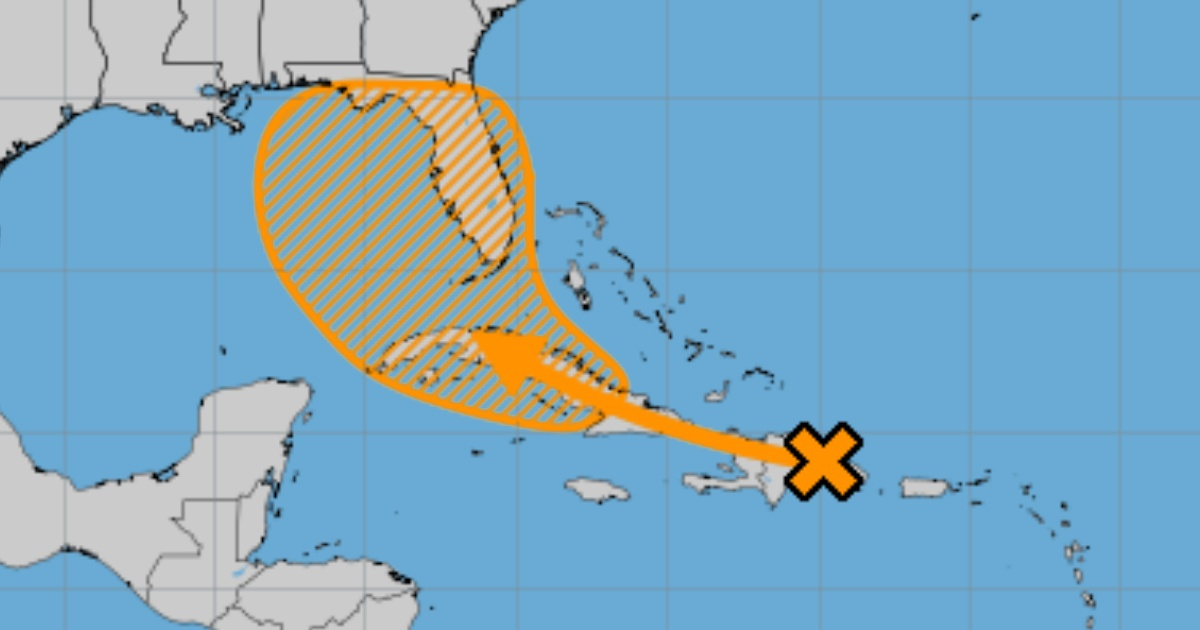
The National Hurricane Center (NHC) reported this Thursday that a well-defined tropical wave is moving westward and could become a tropical depression in the coming days.
At the moment, the phenomenon is producing a large area of disorganized rain and thunderstorms over Hispaniola, Puerto Rico, the Virgin Islands, and the adjacent waters of the southwestern Atlantic and the northeastern Caribbean Sea.
The NHC indicated that the development of the system is expected to be slow as it moves toward the west-northwest over the Greater Antilles region.
The U.S. meteorological entity, based in Miami, anticipated that environmental conditions will be more favorable for development after the phenomenon crosses the Greater Antilles.
It is expected that a tropical depression will form this weekend or early next week near the Gulf of Mexico or Florida.
"The interests of the Greater Antilles, Bahamas, and Florida should continue to monitor the progress of this system. It has a low probability (20 percent) of formation in the next 48 hours and a medium probability (60 percent) in the next seven days," concluded the NHC.
Although the latest bulletin from NHC suggests that the phenomenon is likely to develop after crossing Cuba, the Institute of Meteorology of Cuba has already warned of a deterioration in weather conditions across the country, in line with the rains associated with the tropical wave moving towards the island.
Regarding the phenomenon, meteorologist Raydel Ruisánchez indicated that although "its interaction with land and the presence of dry air limit its development, as it advances westward, where the sea surface temperature is around 30°C and the winds in the upper troposphere are favorable, it could enhance its development."
He called for attention to the possibility of heavy rains that could become intense in localized areas of Cuban territory.
At the beginning of this month, meteorologists from Colorado State University (CSU) in the United States raised their initial hurricane forecast for the current Atlantic hurricane season.
They anticipated that 25 named storms and 12 hurricanes could form, of which six would be of great intensity. They added two named storms and one major hurricane to their forecasts made in early June.
This pioneering group in seasonal hurricane prediction updated its forecast based on the increase in sea surface temperatures averaged in the main hurricane development region of the tropical Atlantic and the Caribbean, which remain close to record warm levels.
These temperatures "provide a much more favorable dynamic and thermodynamic environment for the formation and intensification of hurricanes," the university stated on its website.
Beryl set records by becoming the first hurricane, both in category 4 and 5 of the Saffir-Simpson scale, to form so early in the 2024 cyclone season, which started on June 1 and ends on November 30.
The University of Colorado is not the first organization to forecast an above-average hurricane season.
The National Oceanic and Atmospheric Administration (NOAA) of the U.S. predicted in May a more active than usual season, in which between 17 and 25 named storms would form and up to 13 hurricanes, of which up to seven could be of major intensity.
What do you think?
COMMENTFiled under: