
The National Hurricane Center (NHC) has raised the probability to 40 percent in recent hours that a tropical depression will form within a maximum of seven days near the Leeward Islands, the Greater Antilles, or the southwest Atlantic.
The warning is extremely important for Cuba, which must raise its attention to the maximum regarding the evolution of the meteorological phenomenon.
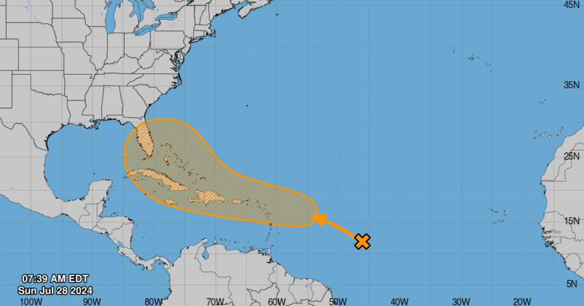
"It is expected that an area of altered weather over the central tropical Atlantic will interact with a tropical wave that is approaching in the coming days," noted the NHC in its 8 a.m. (Miami time) bulletin this Sunday.
"It is forecasted that environmental conditions will become favorable for some development in a day or two, and a tropical depression could form around the middle of the week while the system is near or over the northern Windward Islands, the Greater Antilles, or the southwestern Atlantic Ocean," concluded the entity.
The Cuban meteorologist Raydel Ruisánchez emphasized in information published on Facebook that although the current conditions are not favorable for development, "they could become somewhat more favorable as this system moves further west."
He also reiterated that the area indicated in the forecasts is not a cone of trajectory for a tropical storm or hurricane, but rather a probability area where the system could be forming. In the coming hours, the probabilities may change; they could continue to increase or decrease depending on how the conditions for the formation of the system behave.
At the beginning of this month, meteorologists from Colorado State University (CSU) in the United States raised their initial hurricane forecast for the current cyclone season in the Atlantic.
They anticipated that 25 named storms and 12 hurricanes could form, of which six would be of great intensity.
One day after Beryl hit the state of Texas as a Category 1 hurricane on Monday morning, leaving destruction and death in its wake, the Department of Atmospheric Sciences at the university added two named storms and one major hurricane to its forecasts made in early June.
This pioneering group in seasonal hurricane prediction updated its forecast based on the increase in sea surface temperatures averaged in the main hurricane development region of the tropical Atlantic and the Caribbean, which remain near record warm levels.
These temperatures "provide a much more favorable dynamic and thermodynamic environment for the formation and intensification of hurricanes," the university stated on its website.
Beryl set records by becoming the first hurricane to reach both category 4 and 5 on the Saffir-Simpson scale, forming so early in the 2024 hurricane season, which began on June 1 and ends on November 30.
The University of Colorado is not the first organization to forecast an above-average hurricane season.
The National Oceanic and Atmospheric Administration (NOAA) of the U.S. predicted in May a season that would be more active than usual, with between 17 and 25 named storms and up to 13 hurricanes, of which up to seven could be of high intensity.
What do you think?
COMMENTFiled under: