
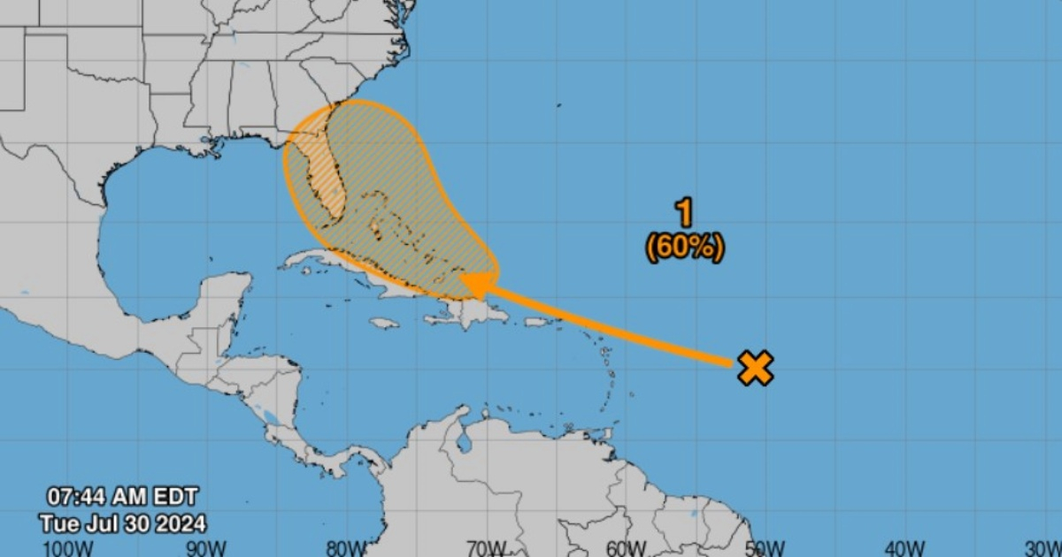
The National Hurricane Center (NHC) has raised the probability to 60 percent in recent hours that a tropical depression will form within a maximum of seven days near the Greater Antilles and the Bahamas.
"A large tropical wave centered several hundred miles east of the Lesser Antilles is producing limited rain activity due to the surrounding dry air," the NHC indicated.
However, the National Hurricane Center warns that soon "conditions will become a bit more favorable for development over the warmer waters of the southwestern Atlantic Ocean," which allows forecasting that by the end of this week a tropical depression could form.
A tropical depression is expected to form near the Greater Antilles or the Bahamas.
For that reason, the US climate agency warns that countries in the Greater Antilles, the Bahamas, and the southeastern United States should closely monitor the progress of the system.
The warning is extremely important for Cuba and Florida, which must raise their attention to the maximum regarding the evolution of the weather phenomenon.
In the most recent forecast from the NHC, the area of potentially affected regions by the phenomenon has shifted more to the north, with less influence on Cuba but much more on the Florida peninsula.
The Cuban meteorologist Raydel Ruisánchez, for his part, confirmed in a Facebook post what the NHC previously indicated.
"The conditions at this time are not favorable for its development due to the presence of dry air. However, it is expected that the conditions will become more favorable as it moves west near the Greater Antilles and the Bahamas, where there is a high content of ocean energy with surface temperatures between 28-30°C," he noted.
The meteorologist added that it is recommended to keep a watch on this system since, regardless of its development, "an increase in rainfall is expected starting this Friday for the eastern and central regions of Cuba, extending to the west by the weekend."
At the beginning of this month, meteorologists from Colorado State University (CSU) in the United States raised their initial hurricane forecast for the current Atlantic hurricane season.
They anticipated that 25 named storms and 12 hurricanes could form, of which six would be of great intensity. They added two named storms and one major hurricane to their forecasts made at the beginning of June.
This pioneering group in seasonal hurricane prediction updated its forecast based on the increase in sea surface temperatures averaged in the main hurricane development region of the tropical Atlantic and the Caribbean, which remain near record warm levels.
These temperatures "provide a much more conducive dynamic and thermodynamic environment for the formation and intensification of hurricanes," the university stated on its website.
Beryl set records by becoming the first hurricane, both in category 4 and 5 on the Saffir-Simpson scale, to form so early in the 2024 hurricane season, which began on June 1 and ends on November 30.
The University of Colorado is not the first organization to predict an above-average hurricane season.
The National Oceanic and Atmospheric Administration (NOAA) of the U.S. predicted in May a more active than usual season, in which between 17 and 25 named storms would form and up to 13 hurricanes, of which up to seven could be of major intensity.
What do you think?
COMMENTFiled under: