
Hurricane Milton remains a highly intense hurricane and is expected to increase in size as it approaches the west coast of Florida, according to the National Hurricane Center (NHC) in its latest bulletin.
"Today is the last full day for Florida residents to prepare their homes and families and, if necessary, evacuate according to the instructions of local authorities," the U.S. weather entity warned.
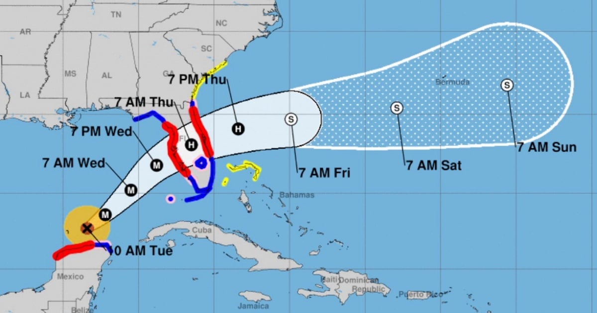
At 10 a.m. (local time), Hurricane Milton was located 205 km northeast of Progreso, Mexico; and 835 km southwest of Tampa, Florida.
In bulletin 14a, the NHC indicated that a hurricane hunter plane discovered that Milton has strengthened.
At this moment, it remains a category 4 hurricane, with maximum sustained winds of 240 km/h (150 mph). Its current movement is to the east-northeast at 15 km/h (9 mph).
It is expected that throughout the rest of today it will continue to turn northeast with an increase in forward speed, approaching the central-west coast of Florida between Wednesday night and Thursday morning.
In the case of Cuba, the Institute of Meteorology (INSMET) indicated that despite "fluctuations in its intensity," Milton remains a dangerous and intense hurricane that will begin to exert its "indirect effects in the western part of the country" starting today.
Among the changes in the NHC's advisory 14 is that the storm surge warning has been extended southward along the east coast of Florida to Port Canaveral.
There is also a tropical storm warning issued for the northwest Bahamas, including Grand Bahama, the Abacos, and Bimini.
Dangerous sea level increases of between 2 and 15 feet are expected in various areas along the coast of Florida, along with large destructive waves.
Rain: Accumulations of between 5 and 12 inches are expected in central and northern Florida, with localized totals of up to 18 inches, which can lead to dangerous flash and urban flooding.
Winds: Hurricane conditions are expected in Florida from Wednesday afternoon until Thursday morning.
Rip currents: The swells generated by Milton will affect a large part of the Gulf coast, with potentially deadly waves and rip currents. The main recommendation is to follow evacuation instructions and stay informed through your local National Weather Service office or the products issued by your national meteorological service.
What do you think?
COMMENTFiled under: