The stunning images of what the eye of the powerful hurricane Melissa looks like from a reconnaissance plane were released this Sunday.
“From a crew member of the Teal 74 mission yesterday towards the now Category 5 hurricane Melissa. As clear as it can be seen in the Atlantic basin,” wrote on X Jeremy DeHart, hurricane reconnaissance pilot.
This morning, satellite images also showed “lightning in the powerful eye of Hurricane Melissa” which has already reached category 5.
A potentially catastrophic hurricane
The hurricane Melissa has intensified its strength, reaching sustained maximum winds of 270 km/h, according to the latest bulletin from the National Hurricane Center (NHC), issued at 11:00 a.m. (Eastern Time) this Monday.
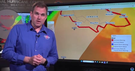
This new figure -10 km/h higher than the previous report- confirms its status as a Category 5 hurricane, the highest level on the Saffir-Simpson scale, and presents a scenario of very high risk for Cuba, as well as for Jamaica, which will be its first stop in the Caribbean.
“Melissa is a category 5 hurricane […] It is expected to reach the southeast of Cuba as a very powerful hurricane,” the NHC warned.
The storm, currently located about 530 km southwest of Guantánamo, is slowly moving west at only 6 km/h, but a turn to the north is expected tonight that could take its center directly over Jamaica and later to eastern Cuba on Tuesday night.
Cuba: Active warnings and potential for severe impact
The bulletin includes a hurricane warning for the Cuban provinces of Granma, Santiago de Cuba, Guantánamo, and Holguín, indicating that hurricane conditions are expected in those areas within the next 36 hours.
In addition, Las Tunas is under a tropical storm warning, and other regions such as the Bahamas and the Turks and Caicos Islands are on alert.
"Tropical storm conditions are expected to begin in eastern Cuba on Tuesday. Hurricane conditions are anticipated to start in the hurricane watch area by Tuesday night."
Cuban authorities have been urged to expedite preparations to protect life and property, especially in coastal and mountainous areas where the impact of the winds could be amplified.
Filed under: