
Related videos:
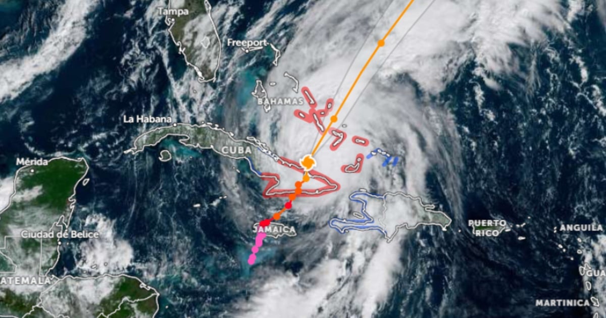
The National Hurricane Center (NHC) reported at 11:00 a.m. this Wednesday that Melissa is located off the east coast of Cuba, now in the southwest Atlantic, with a central pressure of 974 mb and a movement toward the northeast (35°) at 14 mph (22 km/h) and will continue to generate intense rains and swells for the island.
In its latest report, the agency warned that the center of the hurricane is about 245 km south of the central Bahamas and 1,615 km southwest of Bermuda, and it is expected to accelerate along that path in the coming days.
The core of the system will move away from the eastern coast of Cuba this morning, will cross the southeast or central Bahamas today, and will pass near or west of Bermuda late Thursday and into the night.
The NHC maintains a broad advisory: a hurricane warning for the Cuban provinces of Granma, Santiago de Cuba, Guantánamo, Holguín, and Las Tunas, for the southeast and central Bahamas, and for Bermuda; a tropical storm warning for Haiti, Camagüey, and the Turks and Caicos.
Hurricane conditions are developing in Cuba within the area under watch —with expectations of weakening starting this afternoon— while hurricane conditions are anticipated today in the Bahamas and tropical storm conditions in Turks and Caicos.
For Bermuda, the NHC anticipates tropical storm conditions on Thursday and hurricane conditions late Thursday and into the night.
The wind radius confirms the size of the system: hurricane winds extend up to 65 km from the center, while tropical storm winds reach up to 295 km.
The danger from rainfall remains critical. In eastern Cuba, very heavy rains will continue this morning, with totals of 10 to 20 inches and localized maximums of up to 25 in mountainous areas, capable of causing catastrophic flash floods and numerous landslides; it is expected that the pattern of precipitation will decrease in the afternoon.
In the southeastern Bahamas, 5 to 10 inches of rain are expected today, with the potential for flash flooding in vulnerable areas; in the Turks and Caicos, the forecasted accumulation is 1 to 3 inches, while Bermuda may start to experience rain on Thursday or Thursday night.
In Jamaica, overall rainfall has decreased, but an additional 2 to 4 inches could accumulate, bringing the total for the event to 12–24 inches, with isolated areas receiving up to 30 inches in mountainous terrain; the NHC warns that catastrophic flash flooding and landslides continue to pose a threat throughout the day.
The storm surge is also a concern. For the southeast of the Bahamas, a flooding of 1.2 to 2.1 meters above normally dry ground during the day is possible; in Turks and Caicos, minor coastal flooding could occur.
The bulletin adds that there are possible minor coastal floods in bays and inlets along the northern coast of eastern Cuba and along the coast of Haiti.
The waves generated by Melissa will continue to affect Hispaniola, Jamaica, eastern Cuba, and the Cayman Islands for at least another day, and are now impacting the Bahamas and Turks and Caicos, with an extension toward Bermuda by the end of the week, creating rough surf and dangerous currents.
The NHC summarizes that a slight strengthening is possible today and tomorrow, with little variation later as the system moves more quickly to the northeast.
The recommendation for areas under warning is to remain in shelter, finalize preparations where it is still safe to do so, and continuously monitor communications from national meteorological services and civil protection authorities.
Filed under: