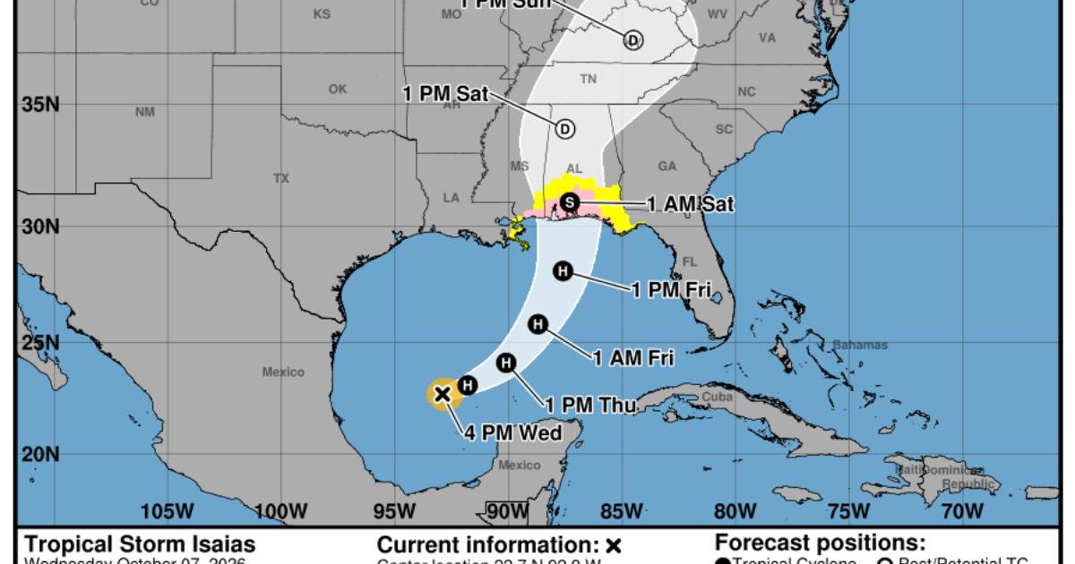
The tropical storm Isaías significantly accelerated its intensification this Wednesday in the Gulf of Mexico and could reach hurricane strength in the coming hours, according to the latest bulletin from the National Hurricane Center (NHC) in the United States.
In its Public Advisory number 5, issued at 4:00 p.m. CDT, the agency reported that Isaías now has sustained maximum winds of 65 mph (100 km/h) and a minimum central pressure of 994 millibars.
The update signifies a significant strengthening in just three hours. At 1:00 p.m. CDT, Isaías had winds of 50 mph and a pressure of 997 millibars.
It is now just nine miles per hour away from the 74 mph threshold that marks the beginning of hurricane classification on the Saffir-Simpson scale.
The NHC predicts it will be a hurricane by Thursday morning
The NHC described Isaías as a system that is rapidly intensifying and anticipated that it could become a hurricane by Thursday morning, with additional strengthening expected until Friday morning.
At 4:00 p.m., the center of the system was located near 22.7 degrees north latitude and 92.9 degrees west longitude, approximately 365 kilometers west-northwest of Progreso, Mexico, and about 805 kilometers south-southwest of the mouth of the Mississippi River.
Isaiah was moving east-northeast at about 8 mph (13 km/h). The forecast predicts a turn toward the northeast and then north on Thursday and Friday.
If the current trajectory continues, the cyclone will pass to the north of the Yucatán Peninsula on Thursday and make landfall at some point along the northern U.S. Gulf coast between late Friday and early Saturday.
No changes in the surveillance, but it could be expanded
The new bulletin did not introduce changes to the existing coastal surveillance measures.
A hurricane watch is in effect from Bay St. Louis, Mississippi, to Indian Pass, Florida, along with a storm surge watch from the mouth of the Mississippi River to Yankeetown, Florida.
A tropical storm watch is also still in effect from the line between Jefferson and Plaquemines parishes to the west of Bay St. Louis, and from east of Indian Pass to the Aucilla River in Florida.
The NHC warned, however, that new watches or advisories may be needed overnight in other areas along the northern Gulf coast.
CiberCuba reported hours earlier about the activation of the first hurricane and storm surge watches associated with Isaias.
Rough seas of up to seven feet and more rain
The NHC maintains the risk of a dangerous storm surge of between five and seven feet, approximately between 1.5 and 2.1 meters, from Ocean Springs, Mississippi, to Indian Pass, Florida, and also in Mobile Bay.
Between Indian Pass and the Steinhatchee River in Florida, the forecast has been adjusted to a surge of four to six feet, while between Steinhatchee and Yankeetown, heights of two to four feet are expected.
The agency also slightly raised its rainfall forecast for the central Gulf coast: between Friday and the weekend, three to seven inches of rain could accumulate, with localized amounts of up to 10 inches.
These rains could cause flash and urban flooding, as well as isolated river rises from the extreme southeast of Louisiana to the Florida Panhandle.
The risk of tornadoes will increase
The new bulletin also includes a more explicit warning about the danger of tornadoes.
The NHC predicts that the potential for tornadoes will increase during the afternoon and evening on Friday as the rain bands from Isaias reach the northeast Gulf coast.
That risk could spread inland on Saturday as the system continues to move northward.
Florida is now under a state of emergency in 25 counties after Governor Ron DeSantis ordered the mobilization of resources due to the potential impacts of Isaias.
If the system reaches hurricane strength in the coming hours, it would also become the first hurricane of the 2026 Atlantic season, following an exceptionally late campaign in achieving that category.
The next intermediate advisory from the NHC is scheduled for 7:00 p.m. CDT and the following complete bulletin for 10:00 p.m. CDT.
Related videos:
Filed under: