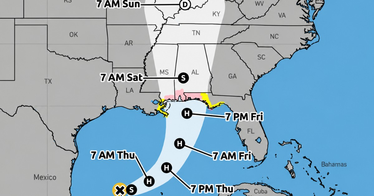
The tropical storm Isaías continues to gain strength in the Gulf of Mexico and could become the first hurricane of the 2026 Atlantic season this Thursday, following an exceptionally calm cyclone season that has already broken records for the delay in registering its first system of that category.
The hurricane hunters from the National Oceanic and Atmospheric Administration of the United States (NOAA) found on Wednesday that the system was strengthening. In the Intermediate Advisory 4A from the National Hurricane Center (NHC), issued at 1:00 p.m. CDT, Isaías had sustained maximum winds of 50 mph (85 km/h) and a minimum central pressure of 997 millibars.
Hours earlier, at 10:00 a.m., its winds were at 45 mph and the pressure was at 1,000 millibars. During the early morning, it had only registered 40 mph and 1,004 millibars, a development that reflects the organizational process the cyclone undergoes as it moves over the warm waters of the Gulf.
The center of Isaías was located about 410 kilometers west-northwest of Progreso, Mexico, and approximately 840 kilometers south-southwest of the mouth of the Mississippi River. It was moving toward the east-northeast at about eight miles per hour.
The NHC predicts that it will become a hurricane on Thursday
The official forecast from the NHC indicates a significant strengthening over the next few hours. Isaías could reach winds of 75 mph by Thursday, thus surpassing the 74 mph threshold necessary to be classified as a hurricane.
If that forecast holds true, Isaiah would become the first hurricane of the 2026 Atlantic season.
The intensity forecast goes even further: the NHC estimates that the cyclone could reach 90 mph on Thursday and up to 110 mph (175 km/h) on Friday while it is over the Gulf.
That final value would correspond to the upper limit of a Category 2 hurricane on the Saffir-Simpson scale, just one mile per hour below the threshold for Category 3. However, this is a forecast of intensity and not a certainty: the final strength of the system may vary depending on its internal organization and the atmospheric conditions it encounters as it approaches land.
In its latest weather discussion, the NHC indicated that it expects Isaías to strengthen into a strong hurricane before approaching the northern Gulf coast on Friday.
A season without hurricanes until October
The potential transformation of Isaías is particularly significant due to the uniqueness of the 2026 season.
The eight named cyclones that preceded it —Arthur, Bertha, Cristobal, Dolly, Edouard, Fay, Gonzalo, and Hanna— did not reach hurricane strength. The season record from the NHC itself maintained zero hurricanes and zero major hurricanes up until the formation of Isaias.
CiberCuba reported in September that 2026 had already set a new record in the satellite era for the latest formation of the first hurricane in the Atlantic.
On September 11, the record shared by the seasons of 2002 and 2013 was officially surpassed. Nearly a month later, the Atlantic still has not recorded its first hurricane.
The season had been forecasted by NOAA to be less active than normal. In August, the agency lowered its prediction to between seven and 13 named storms, between two and six hurricanes, and between zero and two major hurricanes, largely due to the influence of El Niño and the increase in wind shear over the Atlantic.
The danger for the northern Gulf coast increases
The strengthening of Isaías occurs while hurricane, storm surge, and tropical storm warnings remain in effect for parts of the U.S. Gulf Coast.
Hurricane watch extends from Bay St. Louis, Mississippi, to Indian Pass, Florida. The NHC also maintains a surge watch from the mouth of the Mississippi to Yankeetown, Florida.
CiberCuba previously reported on the activation of these alerts due to the strengthening of Isaias, with estimates of swells that could reach between five and seven feet in some areas of the coast.
The NHC warns of an increasing risk of potentially deadly storm surge and damaging winds in parts of the Florida Panhandle, southern Alabama, and Mississippi.
The agency also urged residents in monitored areas to prepare for the possibility of prolonged power outages and to follow the instructions of local authorities.
Florida prepares for the impact
The governor of Florida, Ron DeSantis, declared a state of emergency in 25 counties in the northern and northwestern parts of the state due to the potential effects of the cyclone.
Miami-Dade, Broward, and Palm Beach are not currently included in that declaration, which mainly focuses on the Panhandle and northern Florida.
To the threat of wind and rough seas, rain is now added. The Weather Prediction Center (WPC) maintains a moderate risk of excessive rainfall for the extreme south of Alabama and the western Panhandle of Florida for Friday, where Isaías may arrive already transformed into a hurricane.
The forecasts also consider the possibility of sudden and urban floods, as well as isolated river rises on Friday and throughout the weekend.
NOAA is also monitoring the risk of tornadoes associated with the system as its bands approach Florida and other southeastern states.
Isaías does not pose a direct threat to Cuba
The Cuban Meteorology Institute had indicated after the formation of the system that Isaías does not pose a direct threat to the island.
Attention is now focused on the northern Gulf Coast of the United States as meteorologists closely monitor how fast Isaias may strengthen before making landfall.
Related videos:
Filed under: