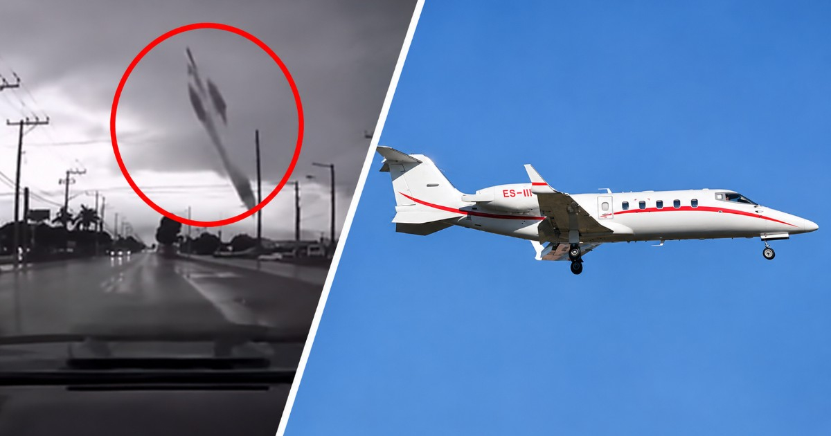
The aircraft that crashed on Sunday, November 1, in Palm Beach County, Florida, was a private Learjet 60, as confirmed by the Federal Aviation Administration (FAA). This official identification contradicts reports that describe the incident as involving a drone or a missile.
The National Transportation Safety Board (NTSB) also identified the model when announcing its investigation. Secretary of Transportation Sean Duffy, confirmed that the nine people on board were killed. The cause of the crash has not yet been determined.
What did the FAA confirm about the Palm Beach plane?
The FAA's statement places the accident around 12:50 p.m. local time, in a residential area near Cresthaven. The plane had taken off from Austin-Bergstrom International Airport in Texas and was headed to North Eleuthera Airport in the Bahamas. The impact caused a loud explosion and a fire next to the homes in the area.
The Palm Beach County Sheriff's Office (PBSO) confirmed an incident involving an aircraft on Military Trail, between Cresthaven Boulevard and 10th Avenue North, and initially announced the closure in both directions. The police statement did not specify the model; the identification as a Learjet 60 comes from federal authorities.
Was it a drone or a missile?
The speed of the fall and the explosion visible in the images can make it difficult to identify the aircraft in the videos. However, the FAA reported that it was a Learjet 60 with nine occupants on a flight route between Texas and the Bahamas, while the NTSB took over the investigation of the incident. The official information does not support that the object was a drone or a missile.
Why did DeSantis say it looked like a missile?
Florida Governor Ron DeSantis described the incident as a catastrophic plane crash and added that it looked like a falling missile. It was a comparison of the shape of the fall and the magnitude of the impact, not a claim that a missile had fallen.
In that appearance, the governor indicated that there were no reports of deaths or injuries on the ground. The nine confirmed deceased were aboard the plane. Duffy's statement did not include their identities.
What is known about the last minutes of the flight?
The platform Flightradar24 associated the flight with the registration N722BD and a Learjet 60 manufactured in 2004. According to the tracking data published, the aircraft made a brief ascent before entering a sharp descent with a right turn.
In the communications with air traffic control recorded by LiveATC and reviewed by Flightradar24, the crew reported ice, moderate turbulence, and precipitation, and requested to climb to 37,000 feet. Shortly thereafter, they reported a rapid descent and an overspeed condition.
Flightradar24 recorded a descent rate exceeding 32,000 feet per minute during that phase. These are tracking and communication data from the flight; there is still no official conclusion attributing the accident to ice, turbulence, or a specific malfunction.
Closures, affected residents, and next steps in the investigation
County Commissioner Joel Flores reported that around 600 people from a mobile home community were being organized for housing and assistance. Authorities prepared shelters and transportation for the residents affected by the access restrictions.
In a subsequent update released by WFLX/WPTV, the county indicated that Military Trail would remain closed between 10th Avenue North and Purdy Lane/Alameda Drive. Haverhill Road and Kirk Road were recommended as alternatives for traveling north to south.
The school district also announced the closure of John I. Leonard High School on Monday, November 2, as emergency operations in the area continued.
The NTSB announced the dispatch of investigators between Sunday and Monday morning, along with a press conference in West Palm Beach scheduled for Monday the 2nd. In its initial announcement, it stated that the time and place of that appearance would be communicated later. The agency will lead the investigation with support from the FAA.
Related videos:
Filed under: