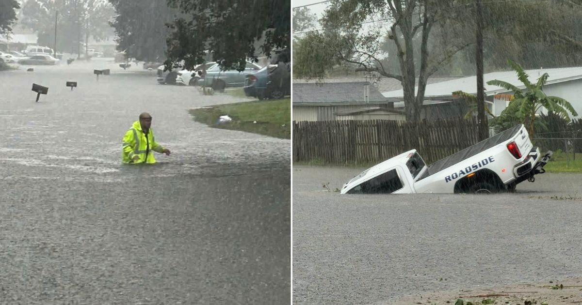
Some areas of Florida received in just 48 hours an amount of rainfall equivalent to almost six months of normal precipitation, with totals exceeding 600 millimeters that caused flooding in homes, trapped vehicles, and road closures.
The American meteorologist Matt Devitt reported on Facebook this Tuesday that approximately 24 inches of rain, equivalent to 61 centimeters, fell in the southern part of Brevard County over the previous two days.
According to his explanation, that amount represents almost half a year's worth of rainfall for the area.
The preliminary measurements released by the Weather Prediction Center of the National Weather Service (NWS) confirmed the magnitude of the phenomenon: between 10:00 AM on Sunday and 9:00 AM on Tuesday, up to 24.10 inches in Malabar and 23.69 inches in Grant-Valkaria, both locations in Brevard County, were recorded.
The amounts correspond to approximately 612 and 602 millimeters of precipitation, respectively, placing those communities among the most affected by the weather event.
In Palm Bay, 20.60 inches were reported, while Melbourne Beach accumulated 19.80 inches. Further south, some stations in West Palm Beach registered up to 22.20 inches, according to preliminary data from the meteorological agency.
The report shared by Devitt also highlighted high accumulations in Palm Beach Gardens, Sebastian Inlet, Sebring, Port St. Lucie, Zolfo Springs, Sunrise, Okeechobee, and Cape Canaveral, although the figures correspond to measurements and estimates from various locations across the state.
The magnitude of the rainfall led the meteorologist to estimate that about three trillion gallons of water fell on Florida during the analyzed 48 hours.
According to their estimation, that amount would be sufficient to fill Lake Okeechobee approximately three times, one of the main freshwater bodies in the state.
Devitt explained that the extraordinary rainfall was the result of a combination of several meteorological factors.
An area of atmospheric convergence that remained nearly stationary concentrated storm activity, while a disturbance provided favorable conditions for humid air to rise and new precipitation to occur.
This was accompanied by an unusually high amount of tropical humidity and a phenomenon known as training storms (successive storms over the same area), in which several rain cells repeatedly pass over the same locations.
This combination caused rainfall to accumulate for hours over communities that were already flooded, exacerbating the damage and hindering the drainage of water.
The meteorologist also highlighted that the event occurred at the beginning of November, a month that typically ranks among the driest of the year in much of Florida.
The rainfall caused significant flooding in several areas of central and southeastern Florida. Water entered homes, left vehicles stranded, and forced the closure of roads that became impassable.
On Monday, the National Meteorological Service declared a state of emergency due to flash flooding in Palm Bay, West Melbourne, and areas of Grant-Valkaria, warning of a potentially deadly situation and the possibility of catastrophic damage.
During the day, meteorological authorities reported that some areas had already received between 15 and 20 inches of rain, and that new precipitation could be recorded over completely saturated ground.
The images of the floods in Brevard County showed streets turned into canals, cars partially submerged, and residents using small boats and surfboards to navigate through flooded areas.
In light of the seriousness of the situation, Governor Ron DeSantis declared a state of emergency in seven counties: Brevard, DeSoto, Hardee, Highlands, Indian River, Martin, and St. Lucie.
The measure, established through Executive Order 26-227, allows for the mobilization of extraordinary resources and accelerates assistance to the affected communities, as well as response and recovery efforts.
Related videos:
Filed under: