Hurricane Beryl gained strength again this Monday as it advances towards the waters of the Caribbean Sea as a dangerous Category 4 hurricane, after briefly decreasing to a Category 3.
At 11:10 a.m. (local time), the eye of Beryl made landfall on the island of Carriacou, in Grenada, with winds of 241 km/h, as reported by the National Hurricane Center (NHC).
Residents of the Grenadines Islands and Carriacou Island should not leave their shelter, as winds will rapidly increase within the eye wall of Beryl, as warned by the NHC.
Shocking satellite images show the powerful eye of the weather phenomenon.
On social media, the first images of the hurricane's damage passing through the small island of Carriacou are starting to spread.
The Space Station has shared an impressive video on X showing the large mass of clouds associated with the weather phenomenon and its wide, perfectly defined eye in the center.
It is expected that the hurricane will move quickly to the west and west-northwest over the next few days. In its projected path, the center of Beryl will move through the southeast and central Caribbean Sea from today until Wednesday.
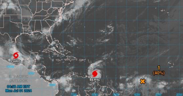
The expected trajectory indicates that it will pass just south of Barbados and then enter the Caribbean Sea towards Jamaica and later Mexico. According to the probable path forecast of the dangerous phenomenon, the hurricane will not affect Cuba.
The government of Jamaica has issued a hurricane alert for the island. Additionally, there are hurricane alerts in place for Barbados, St. Vincent and the Grenadines, Grenada, and Tobago, and a tropical storm warning for Martinique, Trinidad, and Saint Lucia.
There are also tropical storm alerts for the south coast of the Dominican Republic from Punta Palenque to the border with Haiti and for the south coast of Haiti from the border with the Dominican Republic to Anse d'Hainault.
Hurricane season in the Atlantic
Beryl formed on June 28 in the Atlantic and quickly gained strength. It has been the second named storm and the first hurricane of the current cyclone season, which is expected to be very active.
In recent days, the first tropical storm of the season, Alberto, made landfall in northeastern Mexico, where it brought heavy rains that resulted in the death of four people.
On Sunday, June 30, the tropical storm Chris formed in the Gulf of Mexico.
The United States National Oceanic and Atmospheric Administration predicted that the 2024 hurricane season will be well above average, with between 17 and 25 named storms.
It is anticipated the formation of up to 13 hurricanes, four of them being category 3 or higher.
What do you think?
COMMENTFiled under: