
The National Hurricane Center (NHC) announced the formation of the fourth tropical depression of the season, located over Cuba.
Tropical Depression number four has developed rapidly and is expected to cause adverse weather conditions in the region, including the Isle of Youth.
Tropical storm conditions are forecasted with sustained winds of up to 35 mph (55 km/h) and stronger gusts.
It is expected that the depression will produce rain accumulations of between 6 to 10 inches, with maximum totals of up to 15 inches in some areas. These rains could cause flash floods and landslides, especially in mountainous and urban areas with drainage issues.
The depression is moving west-northwest at a speed of 14 mph (22 km/h). It is expected to cross western Cuba before emerging over the Gulf of Mexico, where it could further intensify.
In its latest report published, the National Institute of Meteorology of Cuba (INSMET) indicated that "the predominance of cloudy conditions with showers, rainfall, and thunderstorms will continue over the western and central regions of Cuba."
"The rains could become strong and intense in some areas. It cannot be ruled out that in the areas of showers and thunderstorms, there could be gusts of strong winds, and even local severe storms," he warned.
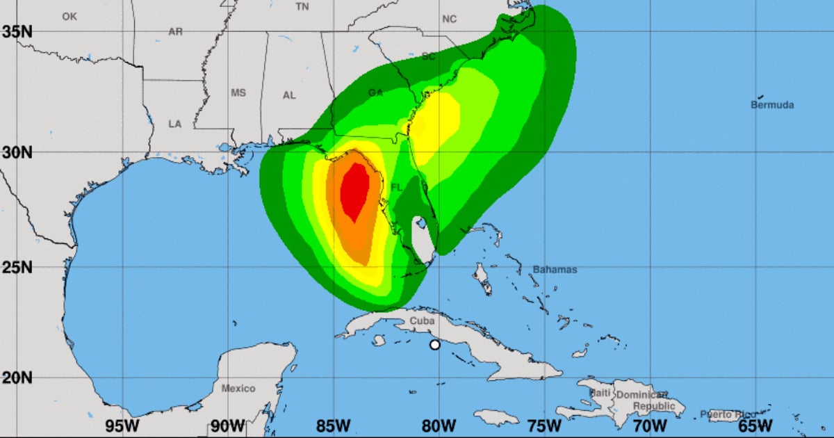
INSMET warned that Tropical Depression Four "can rapidly intensify to become Tropical Storm 'Debbie', which would pose a threat to the eastern coast of Florida and the northern part of that state in the United States." Local authorities issued warnings for the affected areas and recommend that the population stay informed and take the necessary precautions to protect lives and property.
Coastal communities must prepare for storm surges and dangerous waves. It is also advised to avoid traveling in flooded areas and to secure loose objects that may be projected by strong winds.
It is expected that the tropical depression could become a tropical storm once it reaches the Gulf of Mexico.
The NHC issued a hurricane alert for parts of central-west Florida and the Big Bend region, where hurricane conditions may occur late on Sunday.
Tropical storm conditions are expected further south along the west coast of Florida, including the Tampa Bay area, and in Dry Tortugas, where tropical storm warnings are in effect.
The agency also warned of the possibility of potentially deadly flooding due to storm surge along parts of Florida's west coast, from Bonita Beach to the Aucilla River, including Tampa Bay and Charlotte Harbor, where a storm surge watch is in effect.
Cyclone surge impacts, strong winds, and heavy rains may occur in other parts of Florida and along the southeastern U.S. coast, from Georgia to North Carolina, until the middle of next week, warned the U.S. hurricane center.
Residents of the region should follow the instructions from local authorities and stay alert to weather bulletins, the NHC indicated, which will continue to monitor the situation and issue periodic updates.
This Friday, the axis of tropical wave #25, designated as investigation area 97L, brought rain and thunderstorms to eastern Cuba.
The first intense rains occurred in the province of Guantánamo, detailed on social media by Cuban meteorologist Bryam Pérez Valdés.
What do you think?
COMMENTFiled under: