
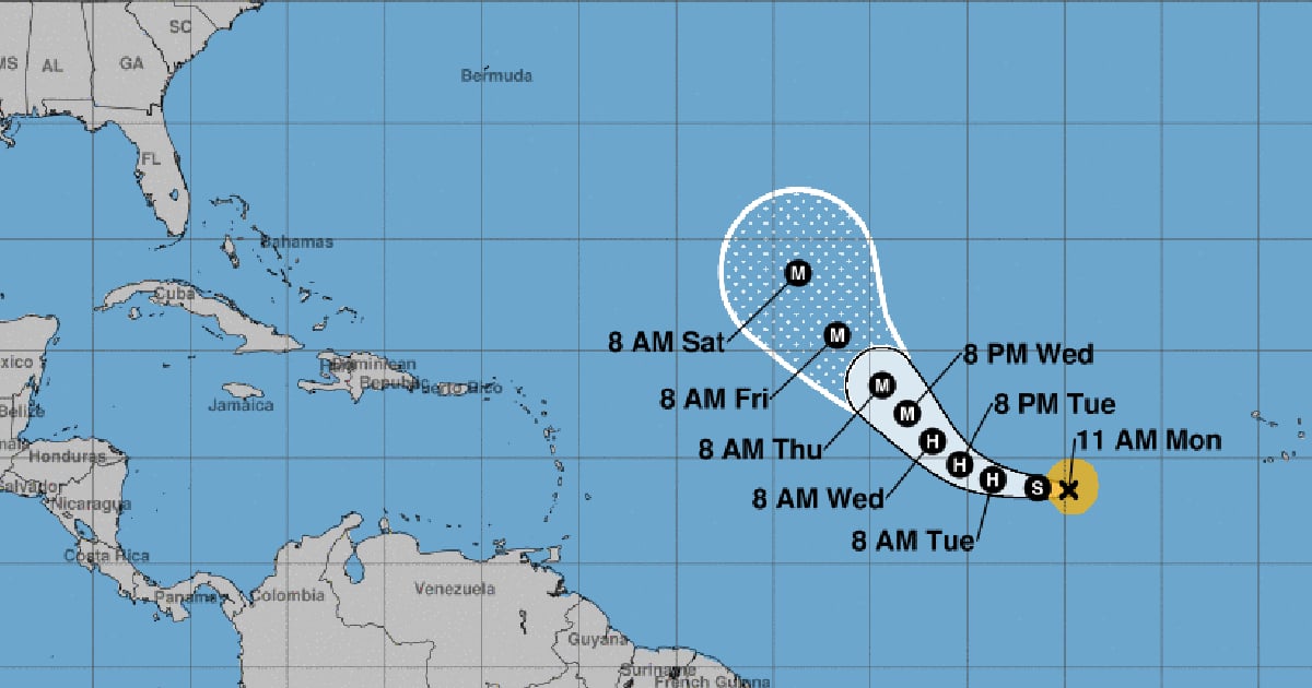
Tropical storm Kirk formed over the Atlantic this Monday, and meteorologists expect it to become a powerful hurricane by the middle of this week.
In its notice number 4 about this tropical system, the National Hurricane Center (NHC) of the United States reported that the maximum sustained winds of Kirk increased to 50 mph (85 km/h) with higher gusts, as it moves westward.
According to experts, it is likely that Kirk will become a hurricane this Tuesday, and could reach a high intensity by the middle of the week.
At 11 a.m., the center of the new tropical storm was located near latitude 13.5 North and longitude 34.8 West, about 740 miles (1,195 km) west-southwest of the Cape Verde islands, and was moving west at approximately 12 mph (19 km/h).
It is expected that the movement of this system to the west and west-northwest will continue until this Tuesday, and it will make a gradual turn to the northwest on Wednesday.
The winds with tropical storm force extend outward up to 115 miles (185 km) from the center, while the estimated minimum central pressure is 1001 mb (29.56 inches), the NHC statement specified.
There are no alerts or coastal warnings in effect for this tropical entity.
On Sunday afternoon, the NHC announced the formation of tropical depression number 12 in the eastern tropical Atlantic - today tropical storm Kirk -, which "could become a formidable hurricane by the end of this week."
Since the morning of this Monday, meteorologists from the NHC have been monitoring a broad area of low pressure in the western Caribbean Sea, in the same location where Hurricane Helene formed, which has caused catastrophic damage and the death of more than 100 people in Florida and other U.S. states.
Currently, that area of low pressure is disorganized but has a 40% chance of development during the week. According to experts, the environmental conditions could become more favorable for its evolution in the coming days, increasing the chances that it will become a tropical depression by the end of the week.
Meanwhile, tropical storm Isaac, located several hundred miles north of the Azores, has lost its tropical characteristics, becoming a post-tropical cyclone.
Meanwhile, Joyce continued to be a tropical depression this Monday, while moving northward over the Atlantic, and there is another area under watch in the eastern Atlantic.
What do you think?
COMMENTFiled under: