
Related videos:
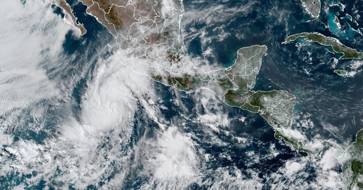
Tropical Depression One-E continues its path in the eastern Pacific, and according to the warning from the National Hurricane Center (NHC), it is expected to strengthen and reach tropical storm status this Thursday.
At 2:00 a.m. Pacific Standard Time (MST), the center of the system was located at latitude 13.3 north and longitude 106.0 west, approximately 1,145 kilometers south-southeast of the southern tip of the Baja California Peninsula, according to the bulletin from the NHC.
The monitoring center emphasized that it has maximum sustained winds of 55 kilometers per hour, with stronger gusts, and is moving to the north-northwest at a speed of 15 kilometers per hour.
In addition, he noted that the forecasting models indicate that this movement will continue throughout the day, with a possible turn toward the north on Friday and Saturday.
However, it was recommended that, although there are currently no warnings or coastal alerts in effect, attention should be maintained on the evolution of the system.
The estimated minimum central pressure is 1006 millibars (29.71 inches), and although it does not pose immediate threats to land, its development will continue to be monitored by the NHC.
For its part, the Mexican government stated that the system will cause heavy rains and elevated wave activity in several central and western states of the country, primarily in the states of Puebla, Michoacán, Guerrero, Querétaro, Tlaxcala, Hidalgo, the State of Mexico, Morelos, Jalisco, Colima, Guanajuato, and Mexico City, reported Telemundo.
The National Oceanic and Atmospheric Administration (NOAA) issued its official forecast for the 2025 Atlantic hurricane season, warning that it will be a “above average” season, with a high probability of significant storms.
The report, presented at a press conference just days before the official start of the season (which runs from June 1 to November 30), estimates the formation of between 13 and 19 named storms, of which 6 to 10 could become hurricanes, and between 3 and 5 may reach major category (category 3 or higher).
NOAA attributes this forecast to several key climate factors: warmer-than-normal surface temperatures in the Atlantic and Caribbean; a neutral phase of the El Niño-Southern Oscillation (ENSO), which does not inhibit the development of cyclones as an active El Niño would; and a more intense West African monsoon, which can generate more tropical waves, the "seeds" that often turn into hurricanes.
The agency estimates a 60% chance of a season exceeding normal levels, compared to a 25% likelihood of being around average and only a 15% chance of being below average.
The NOAA forecast aligns with the one published weeks ago by Colorado State University, which predicted 17 named storms, 9 hurricanes, and 4 major hurricanes, also above the average.
In a normal season, 14 named storms, 7 hurricanes, and 3 major hurricanes usually form.
Frequently Asked Questions about Tropical Depression One-E and Its Evolution
What is the current situation of Tropical Depression One-E in the Pacific?
Tropical Depression One-E is located in the eastern Pacific and is expected to strengthen into a tropical storm. Currently, its center is situated 1,145 kilometers south-southeast of the Baja California Peninsula, with winds of up to 55 km/h. The National Hurricane Center (NHC) is monitoring its development, although it does not pose an immediate threat to land.
What impacts could the tropical depression have in Mexico?
It is expected that Tropical Depression One-E will bring intense rains and elevated waves to several states in Mexico. The affected areas include Puebla, Michoacán, Guerrero, Querétaro, Tlaxcala, Hidalgo, State of Mexico, Morelos, Jalisco, Colima, Guanajuato, and Mexico City, according to reports from the Mexican government.
How is cyclonic activity related to the hurricane forecast for 2025?
The forecast for the 2025 hurricane season anticipates above-average activity compared to historical norms. The formation of between 13 and 19 named storms in the Atlantic is expected, of which 6 to 10 could become hurricanes. This activity is influenced by warmer temperatures in the Atlantic and the Caribbean, as well as climatic conditions such as the neutral phase of the El Niño-Southern Oscillation phenomenon.
What precautionary measures should residents in the affected areas of Mexico take?
People in the affected areas should prepare for heavy rains and possible flooding. It is recommended to stay informed through local authorities and take precautions, especially in areas prone to landslides and flooding.
Filed under: