
Related videos:
The tropical storm Erin, which formed this Monday in the waters of the eastern Atlantic, is expected to strengthen in the coming days to become the first major hurricane of the 2025 season, according to the latest bulletin from the National Hurricane Center (NHC) of the United States.
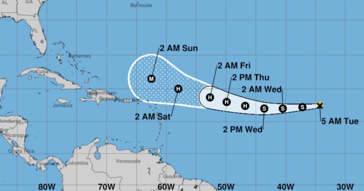
At 5:00 a.m. local time, the NHC reported that the center of Erin was located near latitude 17.4°N and longitude 34.3°W, approximately 1,105 kilometers west of the Cape Verde islands and 3,045 kilometers east of the northern Leeward Islands.
The system maintains maximum sustained winds of 75 km/h (45 mph), with stronger gusts, and is moving west at a speed of 35 km/h (22 mph). The estimated minimum central pressure is 1004 mb.
Tropical storm-force winds extend up to 75 km from the center. At the moment, there are no coastal alerts or warnings in effect.
When will it become a hurricane?
According to the NHC, Erin is expected to begin strengthening soon and over the next few days will continue its movement to the west with a gradual decrease in forward speed, before slowly turning to the west-northwest.
If conditions remain favorable, the system could reach hurricane status between Tuesday night and Wednesday, when it is located in the central region of the tropical Atlantic.
Erin's evolution will be determined by two key factors:
The Bermuda High: This large area of high pressure in the Atlantic influences the path of tropical cyclones, and its position could steer Erin toward the Caribbean or alter its course.
The sea surface temperature: The waters of the western Atlantic are recording values well above the average for this time of year, providing ample energy for the system to gain strength.
Erin is the fifth tropical storm since the current hurricane season began.
The storms Andrea, Barry, Chantal, and Dexter did not reach hurricane strength, dissipating before they could strengthen.
Erin, if it intensifies as expected, would be the first system to confirm projections of a more active than usual season, driven by record ocean temperatures and favorable atmospheric conditions.
The Atlantic hurricane season officially began on June 1 and will continue until November 30.
Meteorologists had warned that 2025 could be marked by the formation of intense cyclones with greater frequency.
Although Erin is currently staying away from populated areas and does not pose an immediate threat, the NHC advises residents of coastal areas in the Caribbean, the Antilles, and the southeastern United States to stay alert to official reports throughout the week, as the system's final trajectory will depend on the atmospheric and oceanic conditions it encounters along its path.
CNN warned that "it is still too early to know how Erin could affect the Caribbean," reminding that at the moment there are no advisories or warnings issued by U.S. authorities.
Monitoring from Cuba
The Cuban Institute of Meteorology (INSMET) issued its first tropical storm alert following the formation of Erin.
The INSMET predicts that Erin will maintain a similar course and continue to gain organization and intensity as it progresses over the open waters of the eastern Atlantic.
Currently, the system does not pose a danger to Cuba, although, due to its position and the time of year, the Forecast Center is closely monitoring its evolution.
Frequently Asked Questions About Tropical Storm Erin
When is tropical storm Erin expected to become a hurricane?
Erin is expected to become a hurricane between Tuesday night and Wednesday, as it positions itself in the central region of the tropical Atlantic, provided that conditions remain favorable.
What is the forecasted path for Tropical Storm Erin?
Erin is currently moving west at a speed of 35 km/h. In the coming days, it is expected to slowly turn towards the west-northwest, influenced by the Bermuda high, which could guide it towards the Caribbean or alter its path.
What factors are influencing the intensification of tropical storm Erin?
Two key factors are influencing the intensification of Erin: the Bermuda High and the sea surface temperature. The waters of the western Atlantic are recording values well above average, providing energy for the system to gain strength.
Does Tropical Storm Erin pose a threat to Cuba?
Currently, Erin does not pose an immediate threat to Cuba. However, the Cuban Institute of Meteorology is closely monitoring its development due to its position and the time of year.
What preparations should residents in coastal areas take in response to tropical storm Erin?
Residents of coastal areas in the Caribbean, the Antilles, and the southeastern United States are advised to stay alert to official reports and review family emergency plans, as the final path of the system will depend on the atmospheric and oceanic conditions it encounters along its route.
Filed under: