
Related videos:
The Forecast Center of the Institute of Meteorology (INSMET) of Cuba issued on the morning of this Wednesday, October 22, its Tropical Cyclone Advisory No. 3, warning that, despite the slow movement of the tropical storm Melissa over the central Caribbean Sea, the system poses a “potential danger” to the island, making it necessary to closely monitor its evolution.
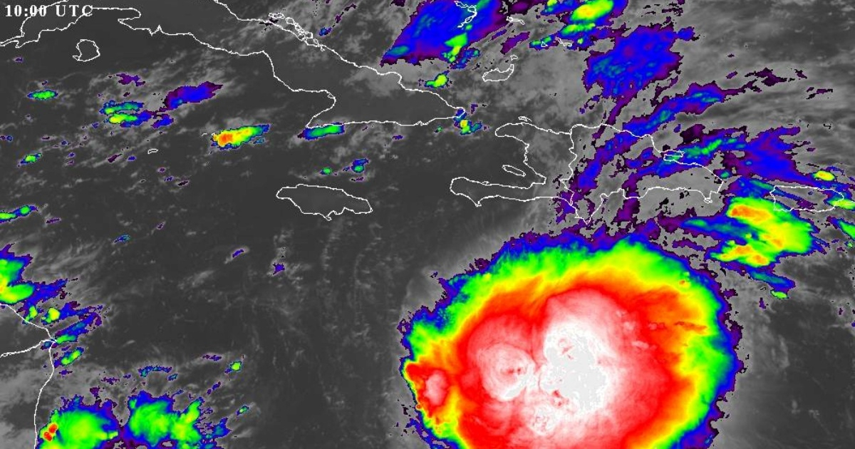
According to the official note, published at 6:00 a.m. (local time) this Wednesday, in recent hours, tropical storm Melissa has shown little change in intensity, although its storm areas have become better organized.
The rain bands associated with the system extend widely over the central-eastern region of the Caribbean Sea, also encompassing the Dominican Republic and Puerto Rico.
At that time, the central region of the cyclone was located at 14.3 degrees North latitude and 73.6 degrees West longitude, which is approximately 495 kilometers south-southwest of Port-au-Prince, Haiti.
Although Melissa continues with maximum sustained winds of 85 km/h, with higher gusts, the central pressure has dropped to 1000 hectoPascals, an indicator that may anticipate a gradual strengthening.
The system is currently moving west-northwest, but its translational speed has decreased to 11 km/h, which, combined with the warm waters of the Caribbean Sea, creates a favorable environment for its intensification.
Forecast for the coming hours: Slow movement and gradual intensification
According to the forecast from INSMET, in the coming hours Melissa will continue to decrease its forward speed, progressively shifting its trajectory toward the northwest and later to the north-northwest.
The system will continue its slow movement over the central Caribbean Sea, south of the Greater Antilles.
Current oceanic and atmospheric conditions are conducive to the system gaining organization and intensity. Therefore, the Institute has reiterated its call for vigilance:
"Given the current position, its slow movement over the warm waters of the Caribbean Sea, and the time of year, the Forecast Center of the Institute of Meteorology is closely monitoring the evolution and future trajectory of this system."
Although a direct alert has not yet been issued for Cuban territory, the possibility that Melissa could affect part of the island cannot be ruled out, especially if the system reaches hurricane category or moves further north.
What is expected for Cuba?
Current forecasts do not place Cuba in the central path of Melissa, but the peripheral effects of the system could be felt in the form of moderate rains and coastal swells, especially in the eastern part of the country, as warned simultaneously by the U.S. National Hurricane Center (NHC) in its latest bulletin.
Accumulations of 2 to 7 cm of rain are expected in the east of Cuba, along with potential rip currents in the next 48 hours, caused by the oceanic activity of the system.
"The latest trajectory models, known as 'spaghetti', as well as intensity models, indicate that Melissa will not leave the Caribbean quickly. This possibility is becoming increasingly unlikely, as the system appears to be taking longer to consolidate, which will push it further west. This scenario poses a greater risk to Cuban territory," warned meteorologist Raydel Ruisánchez on Facebook.
"Melissa will remain for the rest of the week over the very warm waters of the Caribbean Sea, and the winds in the upper atmosphere will become more favorable, suggesting significant intensification to the south of Cuba. Although it may seem contradictory, the fact that Melissa is weak at this moment could turn out to be unfavorable for us in Cuba in the long term, the specialist added."
In recent hours, journalist Lázaro Manuel Alonso shared on social media the update on the two forecast models that pose the greatest threat to Cuba.
At the moment, no direct impact is anticipated as a storm or hurricane, but experts recommend staying alert, especially if the system alters its speed or course in the coming days.
INSMET emphasized, finally, that the behavior of systems like Melissa can change over relatively short periods, urging the public to closely follow the upcoming official announcements, which will be issued at least twice daily as long as the phenomenon poses a threat.
The next announcement from the Forecast Center is scheduled for six o'clock this Wednesday evening, although it could be moved up if there are significant changes in the storm's development.
Filed under: