
Related videos:
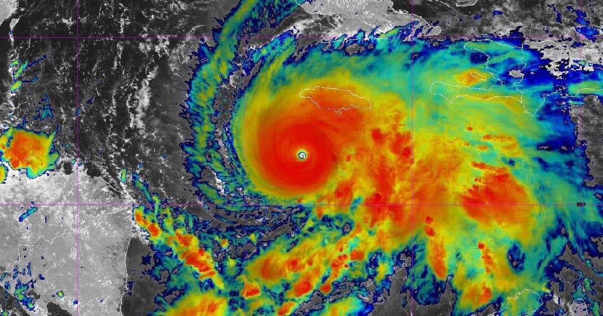
The historian and National Meteorology Award winner, Luis Enrique Ramos, alerted this Monday about the dangers associated with the eye of the hurricane Melissa, which will impact the eastern part of Cuba between Tuesday, October 28, and Wednesday, October 29, according to the latest forecasts.
Ramos, an honorary member of the Meteorological Society of Cuba (SometCuba), explained that the most threatened provinces are Santiago de Cuba and Holguín, although the effects of the phenomenon will also reach the west of Guantánamo and the east of Las Tunas and Granma.
"The hurricane will make landfall in Cuba during the night and early morning, which is something to keep in mind, as in many cases emergencies will need to be handled in complete darkness," warned the expert on the social network .
"Watch out for the eye"
In a post titled “Regarding Melissa, watch out for the eye!”, Ramos reminded that the calm within the eye of a hurricane can be deceptive and deadly if people mistakenly believe that the danger has passed.
"Throughout Cuba's history, there are many instances of people caught in the eye of the hurricane who interpreted the calm as the end of the cyclone and left their homes, only to be struck by the second part of the storm," he noted.
The meteorologist explained that the so-called "eye wall" —a wall of vertically developed clouds surrounding the center of the system— concentrates the most violent phenomena of the hurricane, such as tornadoes, lightning strikes, hail, and destructive straight-line winds.
Gusts, rains, and extreme danger
According to Ramos, Melissa is a powerful hurricane with sustained winds of hurricane strength extending 45 kilometers around the eye, and tropical storm gusts of up to 120 km/h reaching a radius of 315 kilometers.
"The wind will be the greatest danger factor in the area where the center passes," he warned, emphasizing that a gust of 200 km/h can exert a pressure of up to six tons on a standard wall.
The specialist urged the eastern population to maintain discipline, calm, and preparedness, reminding them that "across Cuba, the current situation has a name: Melissa."
Melissa's step
Melissa continues her advance towards the east of Cuba as a powerful category 5 system on the Saffir-Simpson scale, with sustained winds of 270 kilometers per hour and higher gusts, placing it among the most intense cyclones that have threatened the island in over a hundred years.
If it maintains its current strength until making landfall, Melissa could match or even surpass the most powerful hurricanes in Cuba's history, such as those of 1924 and 1932, both category 5 storms considered the most devastating in the country's meteorological records. The 1924 hurricane impacted the west with winds estimated at 265 km/h, while the 1932 hurricane struck the central region with over 240 km/h, leaving thousands of casualties.
In contrast to those historical events, Melissa is heading towards eastern Cuba, an area that has not faced a direct impact of such magnitude and has a more fragile infrastructure and already deteriorated basic services. Experts warn that the combination of extreme winds, storm surges, and torrential rains could cause catastrophic damage in provinces such as Guantánamo, Santiago de Cuba, Holguín, Granma, Las Tunas, and Camagüey.
According to historical data, the most destructive cyclones recorded in Cuba also include Hurricane Michelle (2001), which made landfall as a Category 4 with winds of 225 km/h; Hurricane Ivan (2004), which grazed the west as a Category 5; and Hurricane Flora (1963), whose prolonged rainfall caused more than 1,000 deaths, albeit with lower wind intensity.
Melissa, on the other hand, combines all the elements of an extreme hurricane: sustained winds exceeding 250 km/h, a central pressure below 910 hectopascals, and a slow movement that increases the risk of flooding and landslides. Meteorologists have described its behavior as "explosive intensification," which could make it one of the most violent tropical systems in the recent history of the Caribbean.
If confirmed, its direct impact on Cuban territory at its current intensity would make Melissa the most powerful hurricane to have struck the island since reliable records began. Civil Defense authorities have maintained the Cyclonic Alarm Phase in six eastern provinces, while rescue brigades and electrical technicians are preparing to act once the effects of the phenomenon pass.
The country faces this new challenge amid a complex context: widespread blackouts, resource scarcity, and a limited communication network that could complicate the response to a large-scale emergency. Forecasts indicate that the eye of Melissa may approach the eastern southern coastline between Tuesday night and Wednesday morning, with a destructive potential that could mark a significant moment in Cuba's meteorological memory.
Filed under: