
Related videos:
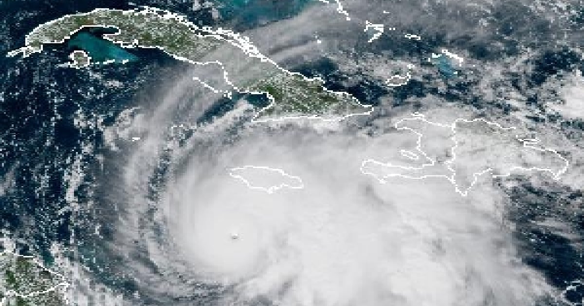
The hurricane Melissa, a category 5 -the highest on the Saffir-Simpson scale-, continues to increase in intensity as it slowly moves towards Jamaica and Cuba, with maximum sustained winds reaching 270 kilometers per hour during the morning of this Monday.
The Tropical Cyclone Warning No. 15 from the Forecast Center of the Institute of Meteorology of Cuba (INSMET), issued at noon today, located the eye of the powerful hurricane approximately 223 kilometers southwest of Kingston, Jamaica; 380 kilometers south of Cabo Cruz, in Granma province; and 480 kilometers southwest of the city of Santiago de Cuba.
The weather report specified that Melissa remains a very intense hurricane, in the highest range of the scale that measures these meteorological events, as its maximum sustained winds have increased to 270 km/h, with higher gusts, and its central pressure dropped to 908 hectoPascals.
The coordinates of the eye of the hurricane were estimated at noon to be 16.4 degrees North latitude and 78.3 degrees West longitude.
Cuban meteorologists forecast that, in the next 24 hours, this system will continue its slow movement westward, gradually tilting its trajectory north and then northeast, moving very close to or over Jamaica.
Starting Tuesday, it will approach Cuba from the seas south of the eastern region, causing weather conditions to progressively deteriorate.
The INSMET warning indicated that the outer bands of the meteor will continue to increase cloud cover and precipitation in the eastern region of the country. The rains may be heavy in some areas, especially in mountainous regions.
In addition, strong swells will continue in the waters south of the provinces of Granma, Santiago de Cuba, and Guantánamo, causing minor flooding in low-lying areas along the coast.
A "catastrophic and potentially deadly" phenomenon
At the beginning of the afternoon on this Monday, the National Hurricane Center (NHC) of the United States provided an update on Hurricane Melissa.
“We expect catastrophic winds”, said the agency's director, Michael Brennan, who described Melissa as a phenomenon that is “catastrophic and potentially deadly.”
Melissa is expected to turn north between tonight and Tuesday, moving over Jamaica in the coming hours and crossing into eastern Cuba on October 28.
"It will move across the east of Cuba on Tuesday night," warned the meteorologist, and it could do so as a category 4 or 5 hurricane. The storm will especially impact the provinces of Granma, Santiago de Cuba, Guantánamo, and Holguín during Tuesday night.
Cyclonic alarm from Guantánamo to Camagüey
This morning, the National Staff of Civil Defense of Cuba declared the Cyclone Warning Phase for the provinces of Guantánamo, Santiago de Cuba, Holguín, Granma, Las Tunas, and Camagüey, due to the imminent approach of Hurricane Melissa.
The provinces of Ciego de Ávila and Sancti Spíritus have been declared in Cyclonic Alert Phase, while Cienfuegos, Villa Clara, Matanzas, Mayabeque, Havana, Artemisa, Pinar del Río, and the special municipality of Isla de la Juventud must activate the defense councils in a reduced composition.
In Eastern Cuba, intense rain and sudden flooding are being recorded, and authorities have warned about the dangers of landslides, strong waves, and high winds.
Below is the full text of Tropical Cyclone Advisory No. 15 from the Forecast Center of the Institute of Meteorology of Cuba (INSMET):
TROPICAL CYCLONE WARNING No. 15
HURRICANE MELISSA …Melissa continues to strengthen south of Jamaica...
Hurricane Melissa has continued to gain intensity this morning. Maximum sustained winds have increased to 270 kilometers per hour, with higher gusts, and its central pressure has dropped to 908 hectoPascals, maintaining its status as a major hurricane, category five on the Saffir-Simpson scale.
At noon today, the center of Hurricane Melissa was located at 16.4 degrees North latitude and 78.3 degrees West longitude, which places it about 223 kilometers southwest of Kingston, Jamaica, 380 kilometers south of Cabo Cruz, Granma, and 480 kilometers southwest of the city of Santiago de Cuba. Melissa is moving slowly on a course close to west at a speed of six kilometers per hour.
In the next 24 hours, this system will continue its slow movement westward, gradually tilting its trajectory to the north and then to the northeast, moving very close to or over Jamaica. Hurricane Melissa will be approaching the national territory from Tuesday, over the seas south of the eastern region of Cuba, progressively deteriorating the weather conditions.
The outer bands of this hurricane will continue to increase cloud cover and precipitation in the eastern region of Cuba, which may become heavy in some areas, especially in mountainous regions. Strong swells will persist in the seas south of the provinces of Granma, Santiago de Cuba, and Guantánamo, with minor flooding in low-lying areas of this coastline.
The Forecast Center of the Institute of Meteorology is closely monitoring the evolution and future trajectory of this powerful hurricane.
The next tropical cyclone warning will be issued at six o'clock this evening, Monday.
Filed under: