
Related videos:
The hurricane Melissa emerged on the afternoon of this Tuesday off the northern coast of western Jamaica and is heading towards the east of Cuba with maximum sustained winds of 230 km/h (145 mph), category 4 on the Saffir–Simpson scale.
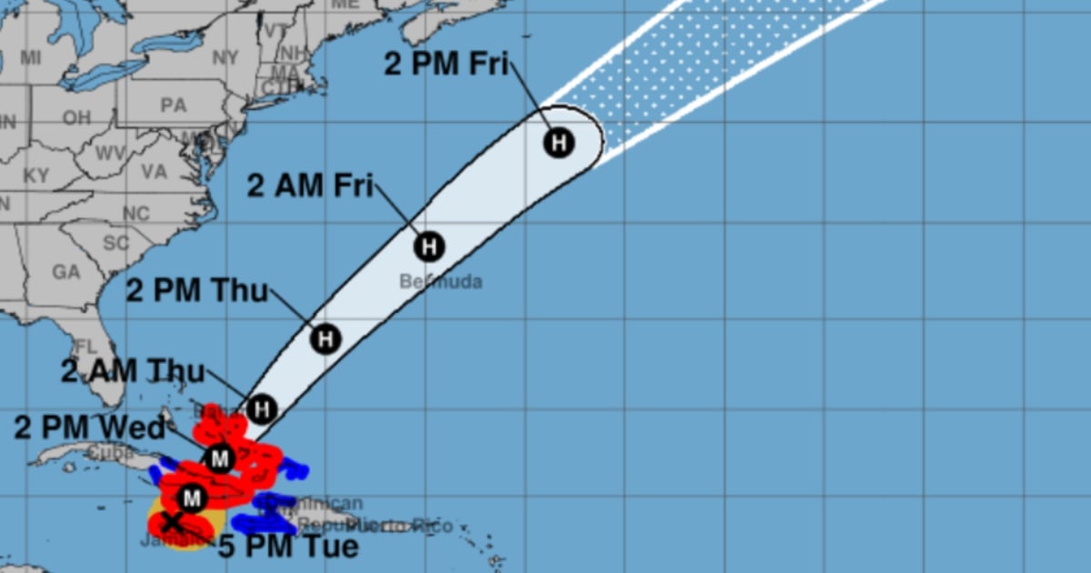
At 5:00 PM EDT, according to the latest report from the National Hurricane Center (NHC), the center of Melissa was located at 18.5°N, 77.7°W, about 20 km east of Montego Bay and 325 km southwest of Guantánamo, with a central pressure of 921 mb and moving northeast (25°) at 13 km/h.
The agency warned that damaging winds, catastrophic flash flooding and storm surge threatening life continue in Jamaica as the afternoon comes to a close.
The official forecast indicates that the core of the system will move away from the west of Jamaica tonight and that the center will shift over the southeast of Cuba between tonight and the early hours of Wednesday.
Later, it will cross the southeast or center of the Bahamas on Wednesday and approach Bermuda between Thursday and Thursday night, making a turn to the northeast with increased speed by midweek.
Even with potential fluctuations in intensity, the NHC expects Melissa to reach southeastern Cuba as an extremely dangerous major hurricane and that it could remain a hurricane as it moves through the Bahamas.
The wind field confirms the magnitude of the cyclone: hurricane-force winds extend up to 45 km from the center, and tropical storm winds reach 315 km.
The NHC has issued a hurricane warning for Jamaica, the Cuban provinces of Granma, Santiago de Cuba, Guantánamo, Holguín, and Las Tunas, as well as for the southeast and central Bahamas; a tropical storm warning is in effect for Haiti, Camagüey, and the Turks and Caicos, and a hurricane alert is in place for Bermuda.
The message to residents in warning areas is to stay or seek safe shelter immediately, and in the Bahamas to complete preparations as soon as possible to protect lives and property.
The risk of rainfall is extreme. Jamaica is expected to receive an additional 6–12 inches, with totals of 12–24 inches and isolated peaks nearing 30 inches in mountainous areas, which will extend the catastrophic flash flooding and numerous landslides until Tuesday night.
In eastern Cuba, the expected totals are 10–20 inches with local maxima of 25, sufficient to cause flash flooding that threatens lives and multiple collapses.
The southern region of Hispaniola is expected to receive an additional 2–6 inches, with total storm accumulations possibly reaching 40 inches in isolated areas; the southeastern Bahamas is forecasted to get 5–10 inches, while the Turks and Caicos will see 1–3 inches, leading to areas of flash flooding.
Regarding the storm surge, the NHC indicates that on the northwest coast of Jamaica, near Montego Bay, a rise of 2–4 feet above ground level is possible, while storm surge flooding on the south coast should subside tonight.
For the southeast coast of Cuba, there is significant potential for 8–12 feet above normal tide levels by late today or Wednesday, near and east of the center entry point, accompanied by large and destructive waves; minor coastal flooding is also possible in bays and inlets along the northern coast of eastern Cuba.
In the southeast of the Bahamas, the swell could reach 5–8 feet, and in Turks and Caicos, it could reach 2–4 feet.
The dangerous waves and marine currents will continue to spread through Hispaniola, Jamaica, the east of Cuba, and the Cayman Islands, and later through the Bahamas, Turks and Caicos, and Bermuda.
Filed under: