
Related videos:
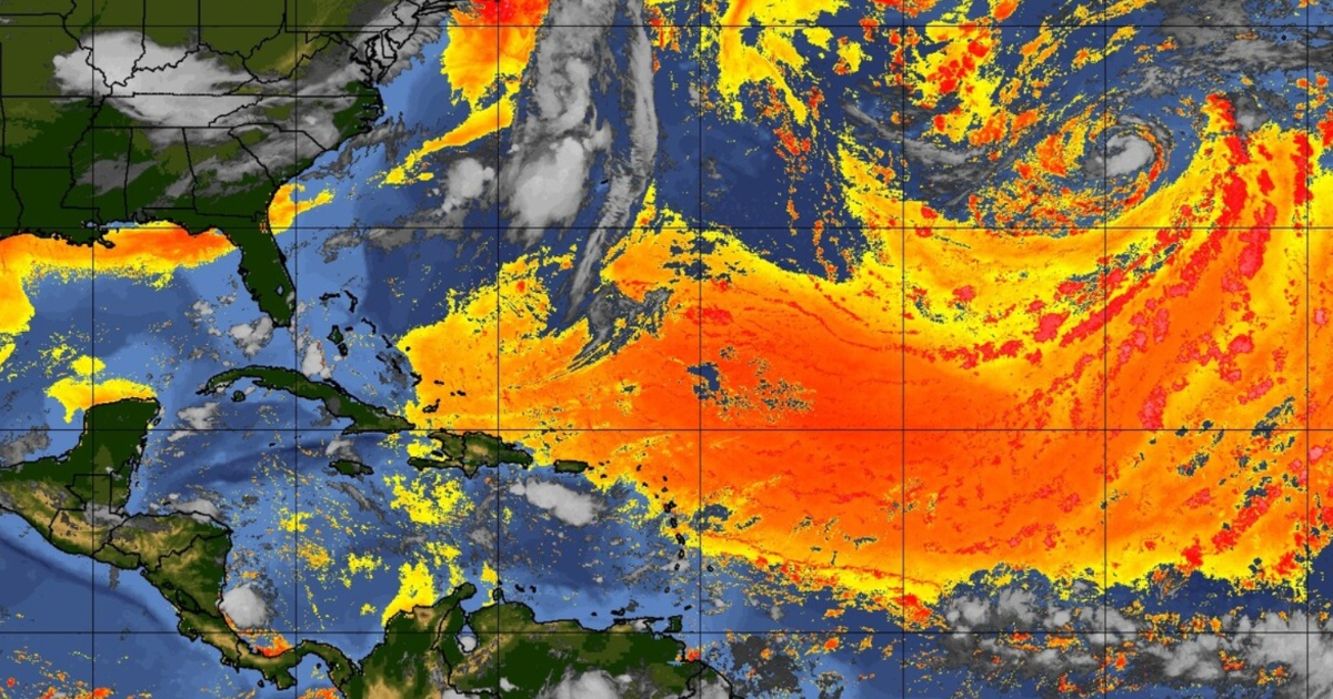
The largest columns of Sahara dust of the year started to cover Florida and the Gulf Coast this Wednesday, with effects that will last into next week, as warned meteorologist Matt Devitt.
"The Saharan dust is here. The largest plumes of the year arrive today in Florida and the Gulf Coast and will continue through next week," wrote Devitt.
The phenomenon did not arrive without warning. Last Monday, Devitt had already warned that several large columns of Saharan dust would move over Florida and the Gulf within a period of 10 days, noting that July is typically the peak of the Saharan dust season for the United States.
Devitt also warned about air quality: dust can create unhealthy conditions in areas where concentrations are higher, particularly affecting individuals with asthma, chronic bronchitis, or allergies.
According to meteorologist Irene Sans from the Florida Public Radio Emergency Network (FPREN), this could be the first significant episode of Saharan dust of the season for Florida, as previous layers had not been dense enough to cause substantial changes in the weather.
The dust began to affect the southern part of the state on Wednesday and reached Central Florida on Thursday, with foggy conditions expected for the northeastern part of the state on Thursday and Friday.
The most immediate impact for residents will be the extreme heat combined with humidity.
With the dust present, temperatures could reach between 95°F and 99°F (35°C and 37°C), with a heat index of up to 110°F (43°C).
The chances of rain will drop to just 20-30%, eliminating the relief that the evening storms usually bring.
The FPREN summed up the situation clearly: "Prepare for dust... and it seems there will be several waves in the coming days. Less rain. Much hotter. Respiratory issues."
Saharan dust travels within the so-called Saharan Air Layer (SAL), situated between 0.5 and 3.5 miles above the surface, covering over 8,000 kilometers from the African desert to the Caribbean and the southern United States.
But it's not all bad news. The phenomenon has a significant positive effect: it suppresses hurricane development in the Atlantic by introducing dry, dusty air that weakens or hinders the formation of tropical storms.
In addition, it creates sunrises and sunsets with especially vibrant colors, and transports phosphorus and other nutrients that fertilize the Amazon jungle.
On the Gulf Coast of Florida, however, the same nutrients that enrich the Amazon can fuel algal blooms and red tide when they deposit into the ocean.
The current episode is not the only one anticipated. A second wave of dust, described as denser, is expected to reach the coast of Texas between Tuesday and Wednesday of next week, indicating that the phenomenon will continue for several more days across the Gulf region.
For historical reference, in July 2024, the conditions were 60% to 70% dustier than usual, with a cloud estimated to be the size of the 48 contiguous states of the United States, one of the largest Saharan dust events ever recorded by the National Oceanic and Atmospheric Administration (NOAA).
Filed under: