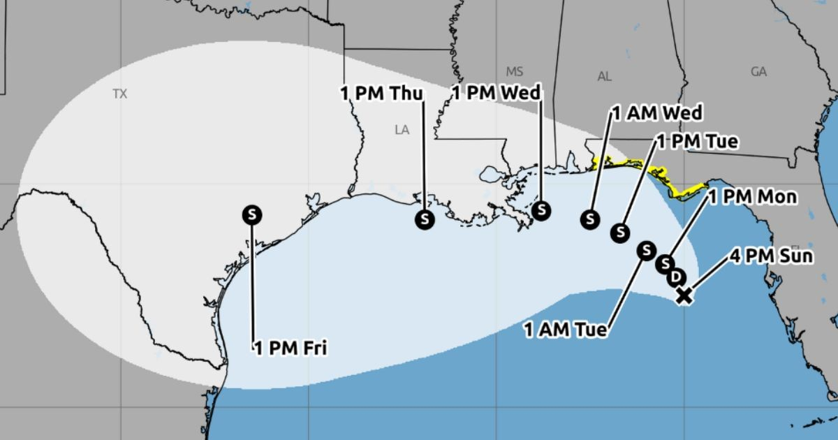
The National Hurricane Center (NHC) issued its second official advisory this Sunday for Tropical Depression Two, a system that is nearly stationary off the west coast of Florida, which could gradually strengthen and bring tropical storm conditions to the northwest part of the state.
According to the NHC advisory number two, issued at 4:00 p.m. Central Time, the system was located near 27.5 degrees north latitude and 85.0 degrees west longitude, approximately 190 miles —310 kilometers— south-southeast of Panama City, Florida.
The depression had maximum sustained winds of 30 mph (45 km/h) and a minimum central pressure of 1,010 millibars. At that time, it was virtually stationary.
For the coastline between the Ochlockonee River and the border between Florida and Alabama, a tropical storm watch was in effect since the initial advisory of the system.
"It is expected that the depression will gradually strengthen and could bring tropical storm conditions to areas of the northwestern strip of Florida starting Monday night," the NHC stated.
The agency predicted that the system could develop into a tropical storm on Monday. If it reaches that category, it will be named Bertha and would become the second named storm of the 2026 Atlantic season. The first was Arthur.
The anticipated trajectory showed a very slow movement towards the northwest or north-northwest for one or two days, followed by a turn towards the west. The center could move near or along the northern coast of the Gulf of Mexico in the following days.
The official forecast for trajectory and intensity predicted a maximum intensity close to 60 mph for Wednesday and Thursday, when the system would move westward.
However, the NHC warned that there was a considerable uncertainty about its development.
In its meteorological discussion, the agency explained that some models showed scenarios ranging from a weak depression to a hurricane, but noted that the broad structure of the system, dry air, shear, and its proximity to land could limit its strengthening.
Alabama, Mississippi, Louisiana, and Texas must monitor the development of the phenomenon, as new alerts or warnings may be necessary in the coming days.
Depression could produce general accumulations of two to four inches of rain, with local maxima approaching eight inches, by Friday.
The precipitation would range from western Florida to the central coast of Texas and could cause flash flooding, especially in urban areas.
A storm surge of between one and three feet was also forecasted from Indian Pass to Chassahowitzka, Florida. Additionally, the wave activity generated by the system could cause dangerous rip currents.
The NHC had been monitoring this low-pressure area for several days prior to officially classifying it as a tropical depression on Sunday morning.
The Colorado State University has reduced its forecast for the Atlantic hurricane season of 2026 to nine named storms, four hurricanes, and one major hurricane, primarily due to the expected strengthening of El Niño.
Related videos:
Filed under: