The tropical Atlantic is showing signs of rapid activation with two systems under close monitoring as they move westward, which are of interest to the Caribbean and Cuba.
One of them has an 80% chance of becoming a tropical cyclone, while a second reaches 50% over the next seven days.
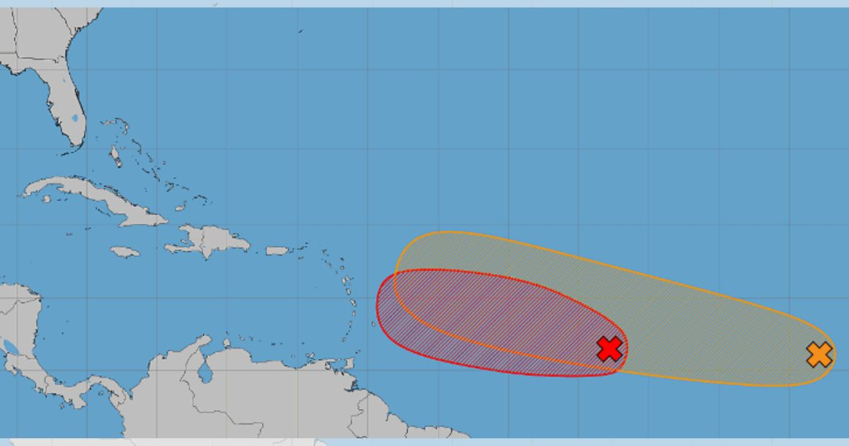
The National Hurricane Center of the United States (NHC for its acronym in English) reported this Thursday that it is monitoring the systems AL92 and AL94.
The first one has a high probability of development, at 80%, while the second is considered to have a medium possibility, at 50% over seven days.
The one attracting the most immediate attention is AL92, a tropical wave located about 1,000 miles east of the Lesser Antilles.
Its rains and thunderstorms are showing signs of organization, and the NHC considers it likely to develop into a short-lived tropical depression over the next day or two as it continues moving westward.
The window for its development, however, could close quickly.
According to the 8:00 a.m. forecast, by late Friday, AL92 is expected to enter an area with strong winds at high altitudes and dry air, conditions that would hinder its further strengthening.
That does not mean that the Lesser Antilles are out of danger. The NHC urged residents of those islands to closely monitor the evolution of the system, as regardless of whether it develops into a tropical cyclone or not, it could cause gusty winds and areas of heavy rainfall between Friday night and Saturday.
AL92 currently has an 80% chance of formation both in 48 hours and over the next seven days.
The system is the same as two days earlier, which had a 70% chance of development as it moved through the tropical Atlantic, so its potential for organization has continued to increase.
Further back is AL94, a tropical wave located several hundred miles south-southwest of the Cape Verde Islands.
For now, it is producing disorganized rain and thunderstorms, but the atmospheric conditions could favor gradual development as it continues moving west or west-northwest through the eastern and central tropical Atlantic.
In this case, the likelihood of becoming a tropical cyclone is still low in the short term: 30% over the next 48 hours.
However, it increases to 50% over the next seven days, and the NHC considers that a tropical depression could form by the end of this week or during the weekend.
The simultaneous appearance of both systems reinforces the warning issued just hours earlier by Cuban meteorologist José Rubiera, who alerted about a "parade of tropical waves" with development potential behind AL92 and urged to maintain close monitoring of what is emerging from Africa and crossing the Atlantic.
"We have 92L, a disturbance with a high potential to become a tropical cyclone in the coming days. Behind it, we have another one, and brace yourselves, this isn't where it ends," Rubiera had warned, noting that the tropical Atlantic was beginning to show much greater activity.
While those two disturbances move westward, Cristóbal has weakened to a tropical depression far away from the Caribbean. The system was located this Thursday about 600 miles west of the Azores and was expected to dissipate, posing no threat to Cuba.
For now, the NHC has not indicated a direct threat to Cuba related to AL92 or AL94, although it is always important to stay alert to weather updates.
The presence of two areas with significant development potential confirms that the Atlantic is entering a phase of increased activity and necessitates keeping a close eye on the systems moving in from the east toward the Antilles.
Related videos:
Filed under: