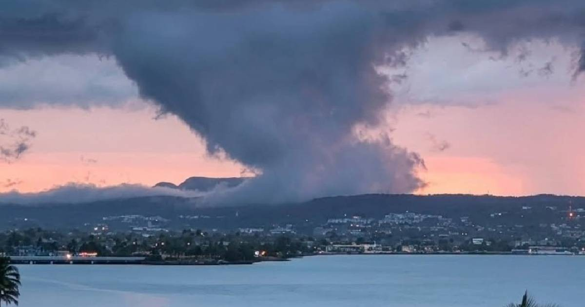
A cloud formation observed over the Yumurí Valley in Matanzas surprised those who saw it due to its unsettling resemblance to a tornado.
The aviation meteorologist Henry Delgado Manzor explained in a Facebook post that the phenomenon poses no danger: it involves pannus clouds, a formation completely different from a rotating vortex.
"It looks like a tornado, but it really isn't," clarified Delgado Manzor. According to the specialist, the pannus are "tattered and chaotic-looking fragments that form beneath cumulonimbus or nimbostratus clouds during precipitation episodes."
Its name derives from Latin and means rag or tattered cloth, directly referring to its fragmented appearance.
"When precipitation falls from a main cloud (such as a nimbostratus or a cumulonimbus), some of that rain evaporates before reaching the ground. This evaporation drastically increases the humidity of the air just below the cloud base. If the humidity reaches the saturation point, small fragmentary clouds form at that level: the pannus," he explains.
The updrafts and downdrafts characteristic of the storm continuously mix the humid air, causing the fragments to form, dissipate, and renew incessantly, explains the expert.
This constant dynamism, he emphasizes, gives them "a chaotic appearance, moving under the main cloud base and even coming together," which explains the confusion with a tornado.
The fundamental difference, however, is decisive: "the pannus lacks the organized rotation and persistent structure" that characterizes a tornado. While a vortex has an intense spin that reaches the ground, the pannus does not rotate nor does it touch the ground.
The World Meteorological Organization classifies pannus as an accessory cloud, meaning it is a formation that accompanies main clouds and does not constitute an independent type of cloud. Its presence usually indicates that there is active precipitation or very close to it, even when the rain has not yet reached the ground at that point.
The Yumurí Valley, located northwest of the city of Matanzas and surrounded by elevations of up to 150 meters, is one of the most iconic natural landscapes in Cuba. Its combination of terrain, humidity, and proximity to the sea makes it an ideal setting for observing striking atmospheric phenomena.
Matanzas has become a recurring setting for this type of event in recent months. In July, there were reports of stunning mammatus clouds over the province, and that same month, a dust cloud from the Sahara arrived, coloring the sky.
In June, two funnel clouds formed within the same cloud in Camagüey, and in April, funnel clouds appeared in two locations in the country.
Delgado Manzor, a meteorologist at the Juan Gualberto Gómez International Airport in Matanzas, is a familiar voice in explaining these phenomena in the province. He has previously commented on episodes of waterspouts, iridescence, rain that evaporates before hitting the ground, and Sahara dust over Matanzas, always with the aim of promoting meteorological knowledge among the population.
Related videos:
Filed under: